Fog along the West Coast of the United States has been documented as far back as the arrival of the Spaniards in the 16th century. Ship captains in later years learned to take it seriously; 100 years ago when the Marine Exchange in San Francisco was asked what proportion of coastal shipwrecks were the result of fog, the reply was “All of them.” Even today, aircraft pilots at coastal airports find themselves trying to stay on the right side of a very delicate balance between clear blue skies and zero-visibility IFR.
Coastal fog or sea fog occurs with great regularity along the coastal regions of the US West Coast. Here, there is a substantial increase in fog days during the summer, with August being the peak month. Geographically, the stretch between San Francisco and Eureka is the foggiest part of the west coast. The statistics show that there are more hours of IMC at SFO than at any other U.S. airport, and the suddenly low conditions can catch the unwary pilot by surprise.
Patterns
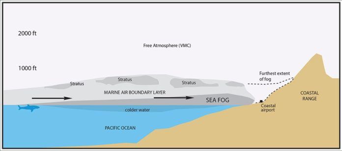
Sea fog forms when a relatively moist air mass overlies a cold ocean surface. This causes the air in contact with the sea to cool, increasing its relative humidity. The temperature of the air mass will not have to fall very much to reach its dewpoint if the air mass is humid. When this happens the air mass becomes saturated and cloud droplets begin forming. This is seen by pilots as fog. The cooling process is not that different from the radiation fog process that happens at night over land.
Along the Pacific Coast, the coldest ocean temperatures are found close to the coast rather than out in the open ocean because there is a tendency for upwelling of colder ocean waters to the surface, particularly when the prevailing flow is offshore. With offshore flow, cold water must ascend to the ocean surface to replace water that has been carried southward or westward. Even if weather conditions change later, the sea surface temperatures remain cool because of the upwelling that had occurred in previous days, and the surface water is slow to warm.
In addition, during most of the year there tends to be a massive prevailing high right off the West Coast. Since this high is centered mostly in the subtropics, the clockwise circulation produces northwest flow in the low levels. This air originates far out to sea over the open ocean and starts out fairly cool and very humid. It then passes over the colder waters along the coast, cools to its dewpoint and saturates, producing fog and stratus. This foggy saturated air mass may then move inland as it continues riding southeast with the winds and reaches the coast.
Do not confuse coastal fog with valley fog or the so-called Tule fog, which forms in inland areas primarily during the cool season. Coastal fog is anchored to the sea and has a tendency to occur mostly in the summer and fall.
A Closer Look
By its nature, fog is associated with an inversion (i.e. capped by a higher layer of warm air), otherwise the humid layer would simply disperse into the atmosphere. Along the coast, the air that is in contact with the ocean, capped by the inversion, is called the marine atmospheric boundary layer (MABL). The depth of the MABL, in other words, the height of the inversion, is generally quite shallow. It is indicated by the cloud or haze top, and this height yields a lot of information about what is happening within.
When the MABL first develops, the air in contact with the ocean is cooling and the inversion begins to form. The depth of the MABL is only a few hundred feet but continues to deepen over a period of days, with stratus layers forming near the top and fog near the surface. At night time, the top of the MABL radiates long wave energy and cools, strengthening the inversion further and temporarily lowering the bases of stratus clouds.
The fog may stay entirely out to sea. In relatively quiet weather conditions, the fog has a tendency to creep inland at night. This may be enhanced if there is a westerly component to the low-level flow. It reaches its maximum inland advance around noon, but then retreats. This is because of solar heating, which “burns off” the edges of the fog by warming and drying the air mass over sunlit land surfaces. This doesn’t always happen, though; a stiff sea breeze, a deep MABL, or strong westerly winds may carry the fog inland and keep it there through the afternoon or, in the extreme, for many days.
Conversely if there are strong offshore winds, such as with the Santa Ana winds, the fog and stratus may be carried out to sea and the MABL dispersed along the coast. But the sea fog may be occurring in full stride out in the islands, such as in the Farallons and Santa Catalina.
Forecasting the Fog
One chart often used by forecasters to anticipate conditions that favor coastal fog in California is the 700 mb chart, which shows conditions at roughly 10,000 feet. The presence of high pressure (high geopotential height) or a ridge at this level corresponds with heightened coastal fog conditions. It is thought that such mid-tropospheric highs are associated with weak sinking motion, which helps reinforce and deepen inversions. The lack of strong winds within a ridge keeps cool air and moisture from dispersing into the atmosphere.
For this reason, the coastal fog is favored in quiet weather patterns, with high pressure or a ridge at the surface or in the middle troposphere. If a large scale storm system is in the area, it will disrupt the MABL and disperse the fog. Though sea fog may be gone, the system may produce bad weather and low ceilings on its own over a broad area, not just confined to the sea and to the coast.
Even with all these tools and the dramatic advances in numerical models over the past 20 years, coastal fog is affected by incredibly small-scale variations of temperature and wind in the air mass. There are circulations that are simply not observable with the current surface network but which can make the difference between fog rolling in or clear blue skies. Furthermore, fog and low stratus have a tendency to follow valleys and low-lying areas, which makes it difficult to figure out exactly when it might reach an inland airport. Because of these factors, there will always be surprises.
What It Means for Pilots
The problem most pilots encounter with coastal fog is not figuring out whether it will roll in or not, but predicting the onset and intensity of the event. Weather services have only a limited ability to track fog since it does not show up on radar, and visible satellite imagery is limited to a resolution of about half a mile and, in practice, 15 to 30 minutes. Updates from the tower and views from the cockpit by far provide the best information.
Another issue is that coastal fog is not well sampled by the surface observation network, most of which are some distance inland, so it will not be revealed simply browsing through METAR reports. Check satellite imagery and be very careful to determine whether you are looking at visible or infrared imagery. Why? Sea fog temperature will closely match the sea surface temperature, so it may be completely invisible on infrared images. If you’re doing pre-dawn planning, a quick look at the previous afternoon’s visible imagery will give a rough idea of the threat since the large-scale fog patterns change slowly from day to day.
Typical fog forecasting rules teach us to check the difference between temperature and dewpoint to see how humid the air is. This rule does not work for coastal fog, since the air mass itself can change as the fog spreads inland. However, dewpoint temperatures offshore, obtained from ship reports and compared with sea surface temperatures along the coast, provide a much better measure on the potential for dense coastal fog: dewpoints similar to or higher than the sea surface temperature favor fog.
When takeoff is only an hour away, pilots and forecasters rely almost entirely on visual information obtained from satellite imagery and direct observation. Model forecasts and timing of coastal fog are not likely to be very accurate. On the other hand, a TAF can be very useful since it is prepared by a forecaster at the National Weather Service and takes into account not only observed data but the forecaster’s own knowledge and intuition.
What if fog closes in on your airport once you’re aloft? Fortunately fog does not advect very far inland, so it’s a matter of having enough fuel on board and knowing how to get to an alternate further inland. Some special caution is needed in northern California where alternates are 50 miles inland and the valleys are filled with redwood forests. This leaves very few places to land, so in an aggressive coastal fog pattern it may be a good idea to spend a couple of extra minutes on preflight checks.
Flying at night along the coast is when you particularly need to be on guard. Delays in your flight plan may result in airfields being worse than you expect due to the nighttime advance of coastal fog. While en route, low clouds can be very difficult to see without moonlight, and things might suddenly go completely dark.
If you’ve recognized a sea fog pattern during flight planning, you’ll remember that the MABL, sea fog, and stratus are all anchored to the ocean and are fairly shallow. Initiating a climb should quickly take you from zero visibility to good VMC. The marine boundary layer is generally not very thick, and only a few hundred feet of climb may be enough to get you above it. If not, you’ll have an extra margin of safety before deciding on your Plan B.
Forecasts are never 100 percent accurate, and surprises occur all the time. One ASRS report from an instructor pilot at San Luis Obispo, after being caught in the air with fog closing in around the airport, summed it up well:
“I’ve canceled many lessons because the fog was close and ‘could possibly’ come in, but never did. I should have discontinued this flight immediately after
I realized how close the fog was. Hopefully my student will learn from my errors and not my example.”
Tim Vasquez also writes the Weatherwise column “Forecast Center.” For more information, visit www.weathergraphics.com/edu.


