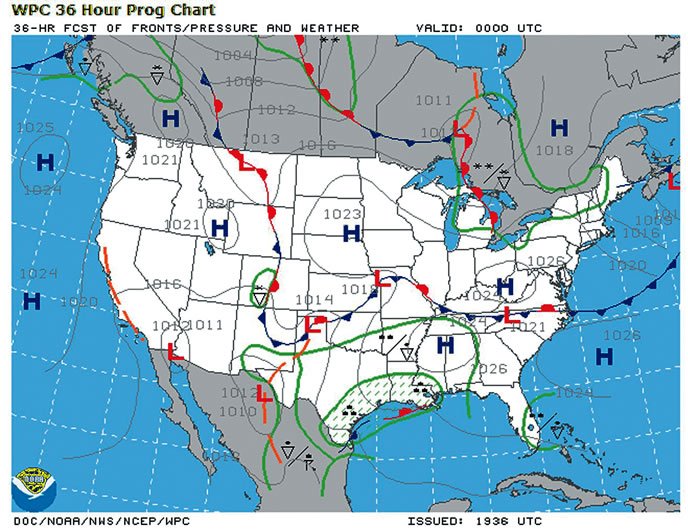
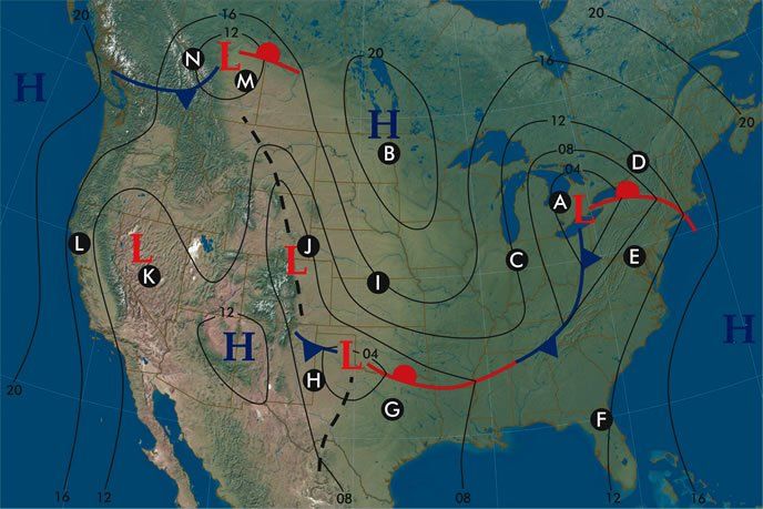
Aviation weather columns typically talk about hazards in terms of elements: “Watch the 0 to -20 degrees C layer for icing.” “Be cautious of wet, clear nights because of fog,” etc. We can always learn more from a change in perspective, and we can do so using surface charts from the Aviation Weather Center website. Using these charts we can get a better understanding of why weather hazards occur rather than how they develop. Let’s take a look at the sample chart below and break down all the patterns that are going on.

A—Near the Frontal Low
There’s a frontal low over Lake Erie at point A, bringing unsavory flying weather. This low is powered by the thermal contrast between the cold air mass over Canada and the warm air mass streaming northward from the Carolinas. This is called a “frontal” or “baroclinic” low.
Even after the low pressure area departs, a broad band of poor weather trails the low, producing a “wraparound” zone hundreds of miles wide. As it passes from west to east, precipitation continues or even intensifies, but gradually dissipates and transitions to showers. There is also a change from low overcast ceilings to scattered to broken ceilings, and from poor visibility to excellent visibility. On this map it’s safe to assume Michigan is under the influence of some of the wraparound, but there’s a good bet that at least some of the airports there, perhaps in the southwest, are reporting VMC.
B—Near the Frontal High
Frontal highs over the northern Plains normally originate from the coldest regions of Canada with strong radiational cooling. These highs sink southeastward and eventually move across the East Coast into the Atlantic. Around the high we get excellent flying conditions. But strong radiational cooling takes place at night. If there is residual ground moisture, be alert to the possibility of radiation fog by dawn.
C—Blustery Behind Cold Front
Immediately behind the cold front, there’s a strong pressure gradient, indicated by the tight packing of the isobar lines, and cold air is advecting in from the north. The cold air is rapidly modifying as it surges south over the warm ground, and this destabilizes it. The result is gusty winds, low-level turbulence, excellent visibility, and if there’s enough moisture, perhaps some showery conditions.
Note that the isobars are packed close together, which identifies windy conditions. This is an area on the weather map where crosswind limits may be a factor. VMC will normally prevail if you’re at least a couple of hundred miles behind the frontal system.
D—Ahead of the Warm Front
In the 1980 film Airplane!, the legendary Captain Oveur announced, “Fog has closed down everything this side of the mountains,” as the cast of characters struggled toward Chicago through thunderstorms. The scriptwriters almost perfectly painted the kind of grim situation that exists across a broad area north of a warm front. Indeed the bulk of IMC weather and hazardous icing conditions occur in this zone, along with a large share of the aviation accidents.
In general, if you don’t have a good TAF or a good briefing to rely on, this area is to be avoided, because almost every hazard in the AIM lurks here. Tropical moisture and overrunning of the warm front means extensive lift and lots of precipitation, and the cool low levels promise a ripe environment for fog. Your best alternates will be found either south in the warm sector or to the north away from the strongest lift. East or westward directions in most cases just bring you into more of the soup.
E—A Textbook Warm Sector
A warm sector is the forecasting term for whatever exists equatorward of the warm and cold fronts. Normally this region is comprised of a tropical air mass that extends from the surface to the middle or the top of the troposphere. The weather here is dominated mostly by diurnal heating, with cumulus clouds and scattered showers during the afternoon and scattered areas of fog in the morning.
Aside from light to moderate turbulence during the afternoon, there are normally no flying hazards here except within showers and thunderstorms, where all the rules about thunderstorm flying apply. Have fun and get some hours in.
F—Subtropical Weather
Springtime is fairly calm in Florida. Like Virginia, the region can rightly be considered under the influence of a warm sector. This warm sector extends to the tropopause. A persistent southeasterly flow with rich tropical moisture dominates the region with widespread VMC.
Daytime hours are characterized by the development of cumuliform clouds, local sea breezes and lake breezes that move inland, and scattered showers along these boundaries as well as old stagnant boundaries from the previous day. IMC may occur in this showery weather but the impact is brief. Nighttime hours are also mostly VMC, but fog and stratus may occasionally develop from residual ground moisture.
G—Great Plains Warm Sectors
Again, we’re equatorward of all the fronts. Just like in the case of Virginia and Florida, the warm sector is dominated mostly by tropical air, lots of cumuliform clouds, warm temperatures, and low densities. However in an active spring pattern, the tropical air over the Great Plains is usually shallow—only reaching an altitude of several thousand feet. Relatively warm, dry air with excellent visibility lies above. This air originates from the desert southwest and offers excellent flying conditions and 100-mile visibility, though when powerful weather systems depart the Rockies, dust from west Texas may infiltrate this layer.
Down below, the tropical air is shallow but is frequently IMC in the mornings. In an active weather pattern, there will be a strong low-level jet in the upper portions of the tropical air, with winds often exceeding 50 knots with a risk of low-level wind shear. During the afternoon ceilings and visibilities lift and the low-level jet weakens. Widespread thunderstorms often move through the warm sector every several days, providing a couple of days of excellent VMC weather before the warm sector pattern returns.

H—VMC Behind the Dryline
The chart shows a dashed line across west Texas, suggesting a pressure trough. But during the spring, this same marking often correlates to a dryline, which separates warm tropical air from dry desert air to the west. The dryline itself is a hotspot for storm development, but what happens out west? Extensive VMC and good visibility, but the atmosphere is unstable and gusty southwest winds are common during the afternoon. Nighttime flying is excellent, but be on guard as sometimes the dryline will recede westward to terminals like AMA, MAF, and LBB and produce nighttime storms.
I—Warm Advection Zone
While a frontal high mostly represents a blob of cold air sinking south, the clockwise pattern of winds means that its western periphery is bringing warm air northward. Much of this warm air actually overruns the front to the south and moves across Kansas and Nebraska at altitudes of 5000 to 10,000 feet.
This overrunning pattern and the upslope flow causes deterioration of ceilings and visibilities, which means terminals in this pattern may be IMC at night and marginal VMC during the day. Also be on your guard for embedded showers and thunderstorms when there is widespread overcast in this pattern.
J—Upslope Flow Problems
Look at that long band of isobars extending from eastern Colorado to Kansas. This represents a broad corridor of southeasterly flow. This is a frequent pattern during the spring, because cold highs move southward through the Great Plains with great regularity. This places the high plains of Colorado, Wyoming, and western Kansas and Nebraska under the influence of cool, moist southeasterly flow. But this actually advects vast amounts of tropical moisture into the high and dry regions of Denver and Cheyenne.
The effect is even further compounded when there are strong westerly jet stream winds lying over Colorado. This helps establish a strong lee-side trough, further amplifying the pressure gradient between the cold high pressure area out east and the low pressures in the Denver and Colorado Springs area.
What does an upslope flow situation mean? First off, you can count on IMC or marginal VMC in western parts of Kansas and Nebraska. Second, if this upslope flow reaches the Front Range of Colorado, you can expect strong thunderstorms by late afternoon at terminals like PUB, COS, DEN, and CYS, which then tend to march eastward overnight in the form of a large squall line. If you’re heading for these destinations in a pattern like this, your best alternates will often be found to the south, away from the conveyor belt of moisture. Pueblo or Trinidad is likely to be in good shape.
You can identify when an upslope pattern exists by confirming southeast winds and looking at dewpoint temperatures across eastern Colorado and the Nebraska Panhandle. Dewpoints exceeding 10 degrees C during the spring months are a good sign that upslope flow may be occurring.
K—A Low in the Great Basin
Quite often you’ll see a low pressure area over Nevada, California or Arizona during the spring months, but there are no fronts and no bad weather. The fact that there are no fronts means that the low is not being fueled by temperature contrasts, so what’s going on?
This is likely a “warm core low” or “thermal low” that is being driven mostly by clear skies, surface heating, and perhaps in this case, lee-side troughing downstream from the Sierra Nevada range. It begins appearing regularly on surface charts around March and becomes especially prominent during the warm season.
Its normal location is southwest Arizona but depending on the pattern it may shift into Nevada or eastern California, and during the summer a trough often extends into the San Joaquin Valley. It should be noted that a deep low with closed contours is common over Arizona from May to September but is rare over Nevada and Utah, so when you see such a low, double-check, because it may actually be associated with a surface front or an upper-level low.
Assuming you have a thermal low, flying weather will be good, with plenty of VMC, but the atmosphere is unstable, so you can expect some light to moderate chop during the afternoon. Problems don’t usually set in until summer when moisture begins infiltrating Arizona, Nevada, and Utah from the south. This produces afternoon thunderstorms that begin mostly over mountains and then expand out into the valleys.
L—Pacific High Influence
During the spring, the semipermanent North Pacific high off the west coast expands and strengthens, bringing cool westerly flow to much of California. This high also blocks frontal systems, keeping them at bay further north in Washington and British Columbia. California also becomes influenced by the warm core low to the east.
If you put this together, you can see that there is an enhanced tendency for air to flow west-to-east, or more properly, northwest-to-southeast across California during the spring months. This means that coastal stratus will have more of an impact on coastal locations and even occasionally spread inland across the Bay Area and Los Angeles. When you see pressure contours stacked along the California coast as you see here, keep tabs on the coastal stratus and plan on having an alternate located further inland.
M—Canadian Outbreak
During the warm season, Canada becomes the hot spot for frontal systems. They may not show up on your typical United States weather maps, but in April and May the patterns are still cool enough to favor them sinking southeastward into the United States. So if you’re flying in the northern Plains, nearly all of your weather changes will be coming from Alberta, British Columbia, and Washington.
Point M is located south of the surface low, so this spot will experience VMC, dry, gusty winds, and some light to moderate chop. Along and north of the front is where you will find most of the visibility and ceiling problems.
N—Where It Gets Serious
We already know from Point A that the weather will remain in poor shape behind the low pressure area due to the presence of wraparound precipitation and clouds. But take a look at the terrain: the Canadian Rocky Mountains cut through this location, and the isobars indicate northeasterly winds. This sets the stage for very strong upslope flow.
In a situation like this, you can count on airports in the foothills and in the mountains to be in bad shape. The normal frontal circulations amplified by strong upslope flow will produce heavy precipitation and widespread low ceilings. Even worse, this area is often near the upper-level low trailing the surface system, which means unstable air and showery weather. If you’re flying toward a zone like this, Godspeed. You will want to have some carefully-selected alternates to the west or northwest.
Tim Vasquez is a professional meteorologist in Palestine, Texas. See his website at www.weathergraphics.com. He’ll gladly exchange some of his perspective for some of yours. Any pilots in east Texas want some weather smarts?


