You can have too many choices, so many that decisions get delayed. It’s usually not a big deal for simpler matters like cruise altitude—estimate what’s best and you can always amend it. But when it comes to approaches and landings on a given runway, the choices are complex and require quick thinking. Throw in VMC, and you’ve got more choices, traffic, and risk.
RNAV to Visual
The weather’s marginal VFR and improving, so the pre-departure planning goes quickly for this trip from Paris, Texas, to Dyersburg Tennessee, to the final stop in Portsmouth, Ohio. It’s a 2.5-hour flight for the first leg, where a refueling stop will get your four-seat retractable ready for another three hours to Portsmouth.
What about the alternate? Most of the smaller airports around will be NA, so why bother? The weather is 2000-5 for hours—no alternate is required. Fine, but there’s always the potential need to divert, so checking this box ensures you’re pre-briefed on a backup, saving workload in the air. Go with Blytheville, Arkansas, 26 NM west. Portsmouth, with area conditions holding at 3000-8, has an even closer alternate: Jackson, 15 miles northeast. You review both and get airborne 20 minutes early.
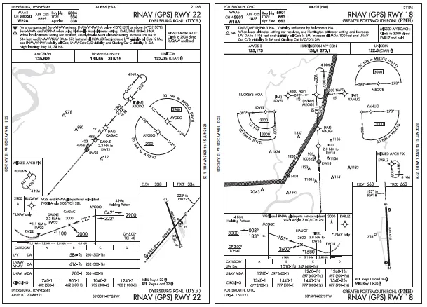
Plan the RNAV 22 at KDYR, with winds southerly at 15 knots. Request vectors as the approach doesn’t have a base leg. Or, get a visual approach to continue descent and get a view of the airport, then shorten the time by entering the standard (left-hand) pattern for 22. Cancel airborne or after landing.
You pick up the AWOS-3PT 30 miles out, which reads 2500-5 now. Then you eavesdrop on the CTAF with Com 2. Between transmissions at other airports on 123.05, you hear several calling “Dyersburg traffic” from various positions. Stay IFR? Go VFR early?
You continue IFR with vectors at 3000 feet, because you haven’t broken out yet, much less entered VMC. The last vector will intercept just outside CAGAC, from which you can call a five-mile final on an IFR approach.
It’d be okay to cancel when reaching 2300 feet (500 feet below the clouds) to focus on communicating with a high-wing on final to coordinate spacing. That worked out great as the aircraft completed a touch-and-go while two others entered downwind, giving you plenty of time to ensure a stable final, but not enough to cancel. Since you hit the approach timer at CAGAC and let it run until parked and shut down, you had a built-in reminder to call ATC.
Clearance, Eventually
After fueling, you regroup for the leg to Portsmouth. For departure, KDYR has a Remote Center Air/Ground frequency to reach Memphis Center. But the warm weather’s getting hot, so you’d rather not sit for long in the airplane on the radio for IFR release. Come to think of it, you also don’t want to get locked into a vector and altitude on departure given the busy VFR activity. Take off and climb out VFR, just remain 500 feet below the clouds. Once clear of the local traffic, ping Memphis Center for an airborne clearance.
Climbing through 1200 feet and turning within the pattern to the northeast, you swap frequencies and wait for a pause in the chatter. Then it appears that ATC is getting back to an aircraft awaiting a popup IFR from Blytheville, coincidentally, and heading somewhere in Alabama. Braced for a longer wait, you head on course and stay at 2300 feet. That’ll work in the chart sector you’re in, with VFR obstacle clearance above 1300 feet. The IFR OROCA is 2500 feet, but as long as you’re visual and can reach ATC, you’re okay.
But fly too far northeast, and there’s Special Use Airspace ahead and a higher OROCA. You slow down to loiter in the area while staying on course. Good call, as you’re only five miles out of KDYR by the time ATC issues the other aircraft a direct-on-course and altitude followed by a squawk code.
Your turn. Um, we don’t see a flight plan for you. Destination? Papa-Mike-Hotel. Standby. Now you’re in popup purgatory. Not IFR yet, gotta maintain VFR. Of course, if weather’s pressing down, a quick clearance to climb would work to get things rolling.
So tell ’em what you need: clearance to climb to 7000 feet on heading 080. That’ll point you to VALER from the original flight plan, a fix southeast of the MOA and Alert Areas ahead. Can do, except maintain 5000, the controller replies. During the climb, you relay the rest of the route: Portsmouth, via VALER and YRK. Then the flight plan does appear. Oops, with the early departure and quick turn, you were nearly an hour early and forgot to advise ATC.
It Gets Busier
The route, designed to bypass the Fort Campbell military airspaces that straddle Kentucky and Tennessee, will still run into other MOAs if you fly the RNAV 18 with a right T-course from JOVEL. The Buckeye MOA starts at 5000 feet and overlaps the Brush Creek MOA (which tops at 5000 feet, so no in-between layer of free space).
There’s also a National Security Area close to where the approach begins on the northwest side, but you only know this ’cause you checked the VFR sectional in anticipation of cancelling at some point. The textual note for the NSA isn’t on the IFR en-route charts: “For reasons of national security pilots are requested to avoid flight at and below 2500’ MSL in this area.” So far there aren’t any reroutes or altitude changes around any of the military airspaces, but you’re glad you didn’t cancel too early and continue on unaware.
With weather holding at 3000-10, it’ll be another busy airport. Again, you check the AWOS, then monitor CTAF. Winds are light from the southwest, five knots. It’s even more crowded and someone’s wanting to land on 36 ’cause he’s flying in from the south. There’s a clearance to 3000 feet, which does get you into VMC, then a cleared-direct to JOVEL.
The approach clearance is moments away. Cancel and head east to enter the pattern from over the field? Cancel and fly the approach on your own? Stay IFR for the visual and have ATC assist with traffic advisories? Stay IFR and fly the approach? Cancel when?
The approach clearance comes in along with advisories of aircraft in the vicinity. Maybe this time it’s best to get the visual so you can maneuver as needed. Stay on the west side to avoid traffic on the left downwind. Of course, this has been done before in the name of traffic avoidance and it’ll happen again, but you know it’s still not what the FAA wants. Advisory Circular 90-66C, an updated version of Nontowered Airport Flight Operations, came out earlier this year and reminds IFR pilots that pattern entries and circling approaches should match the prescribed pattern direction. And, even if on an instrument approach, IFR traffic does not have automatic right-of-way over VFR traffic (right-of-way is still based on the aircraft at lower altitude, but doesn’t cover every situation regarding aircraft position).
Same goes with pattern entries, as the guidelines are written to allow for pilot judgement. That said, you figure the options for a textbook pattern entry now will magnify conflicts, so you decide to wait for the pattern to thin by flying the approach from the west. Get a temporary frequency change to announce your intentions on CTAF, then continue to monitor when back with Approach. It’ll take several minutes to reach a five-mile final, where you can advise ATC you might maneuver to the upwind and enter the pattern.
This you do, and get approved to stay on CTAF. But before switching you cancel, slow down another five knots, squawk 1200, and stop the timer. Someone did land on 36 and cleared the runway before another aircraft turned final to 18. Yikes. Just maintain 1700 feet and break off to an upwind leg, west of 18. After clearing downwind, you overfly to re-enter midfield and land. Only then was there time to see how many times you crossed between IFR and VFR today, keeping way busier than if the weather was low. That’s something you don’t consider often, but will from now on.


