
By Ryan Koch and Jeff Van West
You are part of a flying club with two identical planes based at KHRF. (Pick any plane you’re familiar with that’s capable of mountain IFR.) Since you’re the only instrument-current pilot in the group, the club only needs one GPS data subscription. You usually just swap the cards between planes to make sure you have current data. Except that a club member just took the current data card on a cross-country trip, leaving you with two-year-old data. Fortunately, it’s 17012KT OVC100 10SM over your entire route tonight. Unfortunately, it’s night tonight. (It happens.)
For some reason, it’s really important that you fly a three-leg trip from KHRF, to 3U3, to 32S, and home. Fly it however you would if you had the freedom of VFR, and then come back to answer these questions.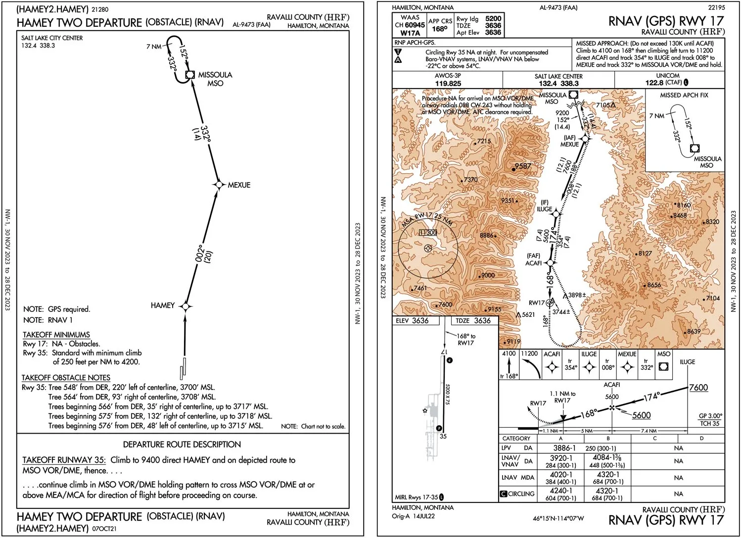
Departing KHRF
You’re making this flight because sim aircraft have really low insurance deductibles. Would you do it IRL (in real life)?
Some pilots have a rule that you get to pick one: night, IFR, or mountains. That could make this a non-starter. For those who would, the level of discomfort would depend on equipment (particularly a second engine or parachute), experience, and local knowledge. Still, this makes a good example of how you might cross the structure and precision of IFR with the freedom and flexibility of VFR.
Could you have flown this IFR with expired GPS data?
If you’re going to use GPS (you are), you must abide by the limitations in the AFM Supplement for your navigator. That varies, but it’s usually something along the lines of this entry from a GTN 750 AFMS:
“GPS/SBAS based IFR enroute, oceanic, and terminal navigation is prohibited unless the flight crew verifies and uses a valid, compatible, and current navigation database or verifies each waypoint for accuracy by reference to current approved data.”
That seems to leave open manually verifying each waypoint’s location for most navigation, and it specifies IFR. So you’re good to go VFR. However, the language on approach procedures is stricter—and it doesn’t distinguish doing that under VFR or IFR:
“GPS or … RNAV (GPS) instrument approaches using the Garmin navigation system are prohibited unless the flight crew verifies and uses the current navigation database.”
If you have an “Xi” GTN, its AFMS likely doesn’t contain the latter note. Maybe you’d get away with simply verifying the waypoints, although the current language of the AIM suggests a current database is required. Regardless, common sense says that if you’re trusting your life to the data in the database you really, really ought to use a current one.
What departure procedure did you pick?
Taking off and turning directly on course will only work until the unfortunate moment right after the mountain is lit up by your landing light. The usual IFR solution won’t work here either: Runway 35 has a direct 12-knot tailwind and Runway 17 is NA for the HAMEY TWO ODP. You could spiral upward in a makeshift VCOA, but the lack of visual references is a setup for disorientation and loss of control or CFIT. Time to get creative.
Maybe you used the HAMEY2, despite the “NA” for Runway 17, by taking off and turning around in a normal traffic pattern. That’s legit under VFR … just know that you’re unprotected until you join the procedure … or at least a safe altitude. The circling minimums for Cat A are roughly 600 feet AGL from the lone approach to Runway 17, so if you can get that high, you have a protected area within 1.8 NM of the runway. Also use your terrain awareness tools, local knowledge, and eyes as you turn around.
Or you might load and use the missed approach for RNAV 17. That’s similar to the above strategy in that you’re not protected at first (the missed approach design assumes a climb from the DA or MDA/MAP, not from the ground). But you could count on the same circling mins as you turn around.
All of these strategies rely on being able to fly the initial climb visually, keeping contact with the airport environment for orientation. While it’s true a Part 91 pilot could technically attempt this even under IFR … uh, well, don’t.
What route did you take to 3U3?
Both the HAMEY2 and RNAV 17 missed approach take you to the MSO VOR. That’s not a bad place to begin the short cruise and arrival to 3U3. But must you go that far north to turn back southeast?
While the OROCA as 13,200, the maximum elevation figures (MEF) on the sectional are understandably lower. Using a profile view in your EFB shows that if you could reach 9000 MSL by Stevensville (32S) you could turn east and continue your climb a bit farther and have ample terrain clearance until joining V86. That would mean gaining about 5400 feet in 17 miles, which is just a bit over 300 feet per NM. That might require a turbocharger at this altitude, but it’s doable.
How high did you fly?
Your biggest obstacle is on V86 at a little over 9000 feet. That’s probably what the 11,300 MOCA is clearing. However, at or above the 12,000 GPS MEA would guarantee communication as well as terrain clearance. (Victor airway MOCAs don’t necessarily assure communication, but GPS MEAs do.) But don’t you have to fly at either 11,500 or 13,500 in this direction VFR? Only if you’re more than 3000 feet AGL.
Of course, you might choose to fly higher for comfort. Or at least to have more time to think about what awaits you after an engine-out. However, the 12,000-foot overcast is around 15,000 MSL here, and you’re VFR.
Arriving 3U3
What strategy did you use to land at 3U3?
Now it’s time to descend, and you’d sure like some instrument guidance in the dark here. The VOR/DME or GPS-A approach is the only option, and as of this writing the latest amendment is about a year old. That means without current GPS data it might well not match the procedure. Presumably, the VOR hasn’t moved, so a good strategy could be using the GPS to navigate in OBS mode, backed up by the actual VOR and your eyes out the window. Make sure you have all your terrain-avoidance tools at the ready: GPS and EFB terrain displays and alerts, and synthetic vision. The approach sets you up neatly for a left downwind for Runway 17, where you can make a normal pattern and landing aided by a PAPI.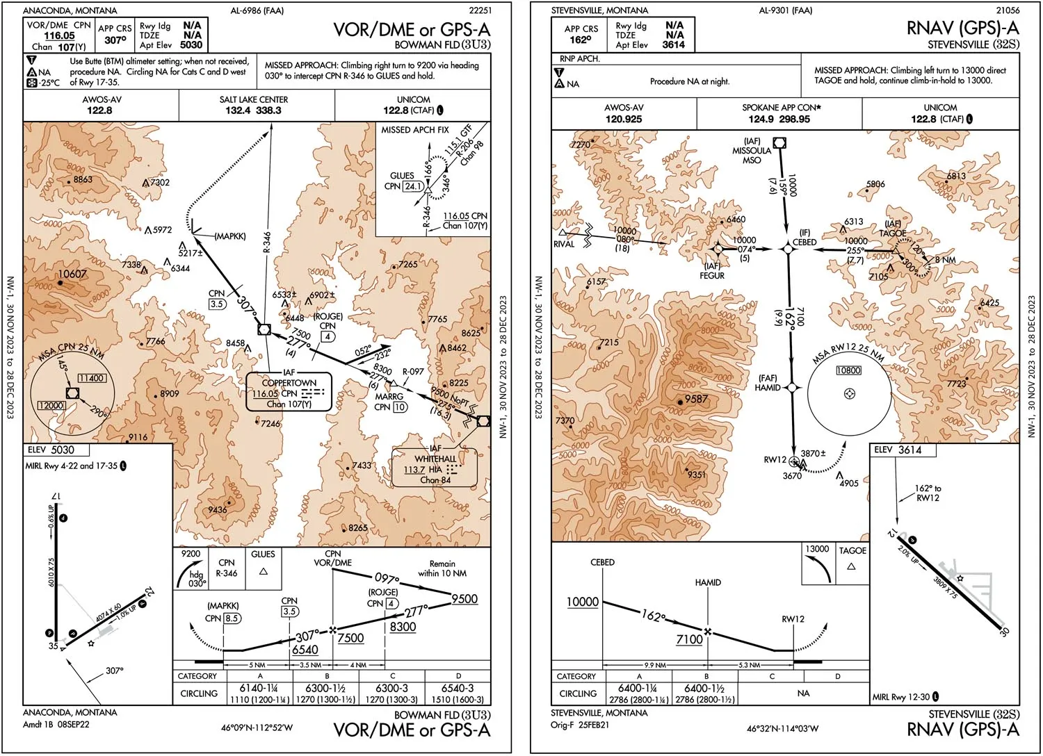
Departing 3U3
How did you depart 3U3?
There’s a VCOA option here where you could climb visually to 7700 (about 2700 AGL). But read carefully, because that’s not all. After the visual portion, you must still “proceed via CPN R-309 to CPN VOR/DME, continue climb-in-hold to 10,200 (north, left turn, 166 degrees inbound).” If you miss that portion of the VCOA and simply turn on course, CFIT is a distinct possibility.
Alternatively, the ODP also ends up at the CPN VOR followed by the same climb in the same holding pattern, but without the initial visual maneuvering. The downside is a minimum climb of 321 feet/NM to 10,200 feet.
Then again, you’re VFR. If the path enroute is clear you’re allowed to skip the hold and turn on course whenever you like. You just better be certain, and the IFR procedure offers that certainty.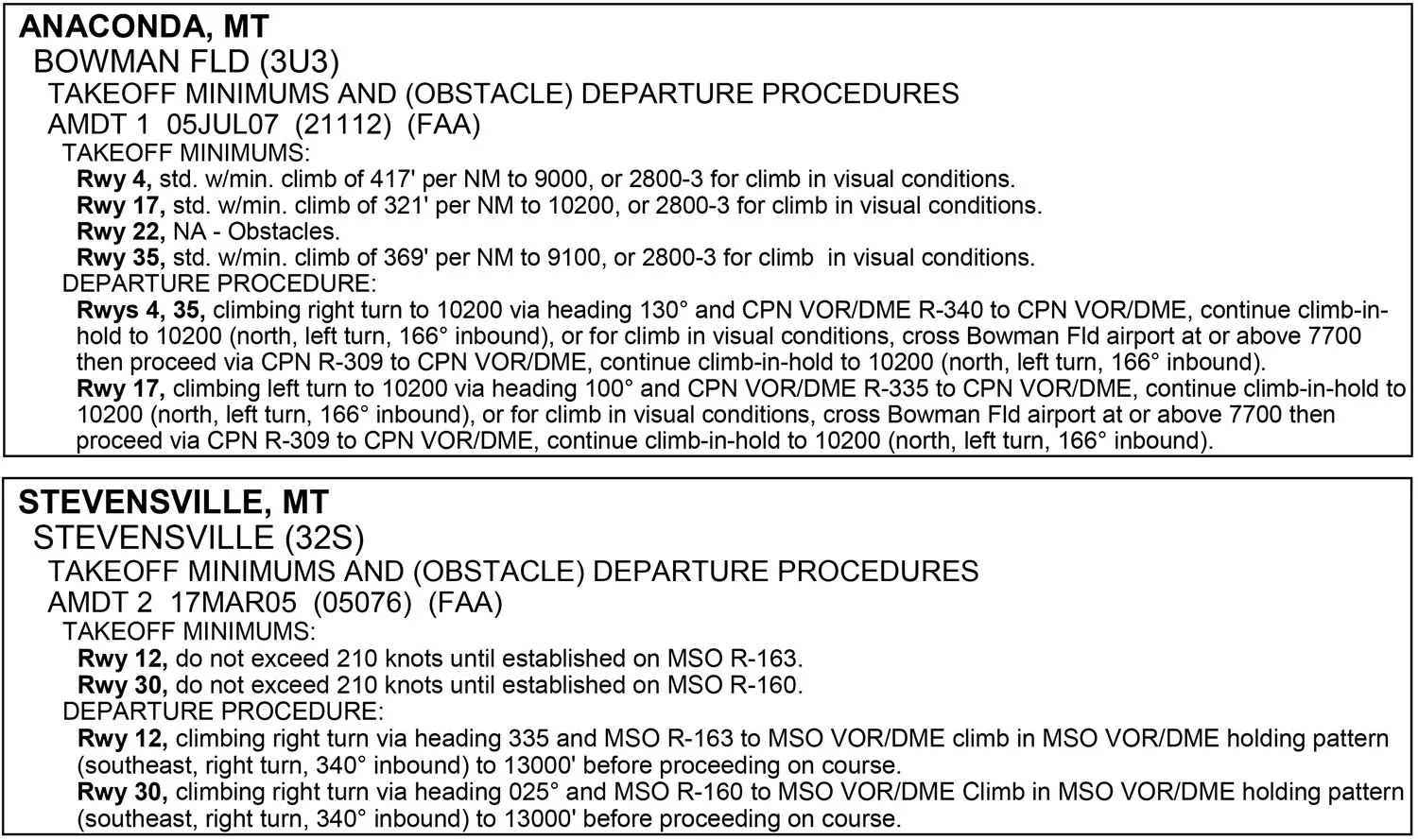
Arriving 32S
How’d you get into 32S?
You’ll again want safe altitudes all the way, and the only approach is the RNAV-A which conveniently offers an IAF at TAGOE on V86. This was published before your GPS database, so while you may not be able to use it under IFR you know its data is accurate.
But then it gets trickier. This approach is NA at night, indicating that there must be unlit obstacles below MDA. And that MDA is nearly 3000 feet AGL. At least there’s a PAPI for Runway 12, which should assure obstacle clearance within 10 degrees and 3.4 NM from the runway. At 3.4 NM it’s still only around 1000 AGL and you’re approaching from 40 degrees off the runway centerline. So you’re on your own between MDA and pattern altitude and during any flight left of the approach course until you line up with the runway and the PAPI. Maybe it would be best to overfly the field and descend into a pattern to then land. Or maybe this just isn’t a nighttime airport. Proceed with caution.
32S to KHRF
How’d you manage the final 16 miles of this challenge?
You could’ve given this the full IFR treatment (albeit under VFR) including the ODP with a northbound climb to at least 13,000, a climbing holding pattern, and a long approach. That’s fine, but overkill for this short VFR leg.
The profile view from your EFB shows a maximum terrain height on the direct route of only 4091 feet MSL with a four NM corridor. Turn on course and you’ll be above that terrain within 500 feet AGL. Sure, that early right turn is in conflict with the AIM’s recommended departures, but if you had to depart here the turn away from terrain and toward city lights is a reasonable compromise for safety. Then you might head to ACAFI, which is on the direct route, for a convenient straight-in approach. Or alternatively, use the Category B circling minimum for a safe minimum altitude to maneuver, in this case within 1.8 NM of the runway.
Both Ryan and Jeff gave themselves overdue holiday presents of upgraded computers, which should make for some really well rendered gray while inside those clouds. No word yet on whether the new computers will make for more difficult sim challenges in the future.


