
Today’s Sim Challenge begins on the ramp at Silver Springs, Nevada, (KSPZ). You can use real-world weather, but since it’s probably good VFR in this part of the country, set up an “under the hood” view in the sim that only shows the panel. We’ll tell you when to go under the hood and when you’re allowed to look up.
Setup … and Go
Using the hood might seem like an odd choice in the sim where you can customize the weather to your liking. The benefit is that real weather comes with complex winds and pressures that change over time, space, and altitude. Since you didn’t set the weather, you won’t know exactly what it’s going to be. You’ll need to pay attention like you would in the real world. It also means this challenge can be slightly different every time you fly it.
Your flight plan remarks indicate list practice approaches at Reno (KRNO), Truckee (KTRK), and Reno/Stead (KRTS). Assume you filed direct Reno International (KRNO) and got: Cleared to KRNO via direct HZN, direct. Climb and maintain 12,000.
Don your virtual Fogglesright after takeoff and fly whatever is appropriate to head for HZN legally and unscathed. After reaching 12,000, NorCal Approach tells you you’re cleared direct BELBE, maintain 12,000 until established, cleared ILS Z RWY 17R, and asks how the approach will terminate. Reply that it’ll be a low approach and that you’d like the RNAV (GPS) Rwy 20 at Truckee (KTRK) next. Fly the approach and the published missed approach procedure. Passing 12,000 on the missed approach, you’re cleared for the RNAV Rwy 20 via WUDPA. Maintain 12,000 until established. Fly that approach and the published missed. Finally, at AWEGA, you’re cleared direct CEVAP at 13,000 and then cleared for the ILS Rwy 32 at Reno/Stead (KRTS). Take the “hood” off when you reach minimums. Land and debrief.
Sound simple enough? Well, maybe…
Departing KSPZ
Did you go exactly the wrong way?
Unlikely? Actually, there are multiple ways that could’ve happened. First, if you took off on Runway 24. The only procedure for that runway is a VCOA. Since you were going under the hood immediately after takeoff, the “visual” part wasn’t going to happen. Hopefully you either took off on Runway 6, or canceled the flight if that wasn’t possible due to a tailwind. (Hey, we told you this would be different every time.)
The ODP involves intercepting the 200-degree radial to HZN. Be careful: that’s R-200 to the VOR, or a course of 020. The text may seem ambiguous, but it’s clear that you must end up flying to the VOR (not away from it) if you’re going to accomplish the next task: climbing in a holding pattern.
Once reaching the VOR, there’s another opportunity to fly exactly the wrong way. You must hold on a 211-degree inbound course. That’s nearly opposite the 200-degree radial you were just flying. It’s almost like the text was purposefully written to confuse. We swear we just found it this way.
What minimum climb was required?
There’s no climb gradient published for either runway, so of course … it’s different for each runway. For Runway 6 and the published procedure it’s the IFR “default” of 200 feet per NM. For the VCOA there is no requirement—at first. While climbing to cross the airport at or above 7000 feet, you’re meant to avoid obstacles visually rather than vertically. But Runway 24’s procedure doesn’t end there. Next, you must proceed to the HZN VOR on the 220 radial before continuing on course. This part you could do IMC, so don’t go the wrong way, and make sure you climb at least 200 FPNM.
KRNO ILS Z RWY 17R
BELBE is an IF, not an IAF. When is it acceptable to start an approach at an IF?
For ATC to clear you to an IF to begin an RNAV approach, the angle of the turn must not be greater than 90 degrees. Can’t find BELBE as a transition option in your GPS? Choose KLOCK, and then delete KLOCK from the flight plan or just go direct BELBE.
Did you have the required equipment to fly this approach?
The first requirement in the chart notes is DME. No worries; you have an IFR GPS.
What about “RNP APCH – GPS”? An approach titled RNAV (RNP) is likely one you cannot fly. At the time of writing, those are all “Authorization Required” and say so on the chart. If you don’t know if you’re authorized, you’re not, but they are published, so check them out. However, in this context the note simply means your GPS must meet the Required Navigational Performance (RNP) for RNAV approaches—as any IFR approach-certified GPS does. Eventually, all approaches requiring RNAV will have that note, but not all charts have been updated to the new standard.
![]()
Finally, from HOBOE or KLOCK, you must have “RF” capability. RF is “radius-to-fix,” which allows flying curved RNAV segments. Modern GPS units like Garmin’s GTN series can handle RF legs provided a bunch of conditions are met. (For example, an electronic HSI with auto-slew capability must be installed.) Older units, like the GNS series, can’t do RF at all. Read your AFMS. If you can’t do RF, you must use a different transition to join this approach.
What line of minimums did you use?
With all the RNAV quirkiness here, it would be easy to forget that this is an ILS approach at heart. It also has two lines of ILS minimums. If you want the lowest line of minimums you’ll need to meet the requirements associated with the asterisk. You’ll find one in the notes section, which allows 1800 RVR if a flight director, autopilot, or heads-up display is used to DA. Handy, but not a requirement. But wait … there’s another asterisk in the missed approach procedures that says you must be able to climb at least 390 feet per NM to 8000 feet.
If you can’t do that, you’re stuck using the next line of minimums. The hashtag symbol there refers to the note increasing minimum visibility if approach lights are out of service. So what if you can meet the climb gradient, but the lights are out of service, but you have a working autopilot, but it’s only a single-axis one? It’s not Vegas, but gambling is still legal in Reno.
Suppose you negotiated with ATC to get vectored onto the approach just inside WALAR at 8000. Could you have waited at 8000 feet for the glideslope to center?
No. ZOMPO is a mandatory 7500-foot altitude, as indicated by the lines above and below. It’s two miles from DISCS, which shows you at 7400 feet if on glideslope. Using 310 feet per NM for that 3.10 glideslope as a rough estimate, centered on the glideslope would be around 8020 feet at ZOMPO.
KTRK RNAV (GPS) RWY 20
How did you manage the ridiculous number of stepdowns inside the FAF?
Most modern GPS navigators will provide “advisory” vertical guidance on this approach. This will appear as a normal glidepath and, on Garmin devices, an “LP+V” annunciation. You can even couple the autopilot to it. Contrary to popular belief, “+V” guidance is designed to clear stepdowns inside the FAF. However, it’s not an official part of the approach, so it’s wise to verify that it actually does. Advisory guidance offers no guarantees below MDA, so you’d better be using your eyes by that point.
When did you “look up” for the runway?
Because this is practice, you might have continued to the MAP at WINUB. But that would be a descent of at least 582 feet in about a mile, or almost six degrees. The VDP at 0.7 to WINUB is a more practical point to continue below MDA or go missed, depending on what you see. An advisory (+V) glideslope will probably reach MDA somewhere nearby if not exactly at the VDP.
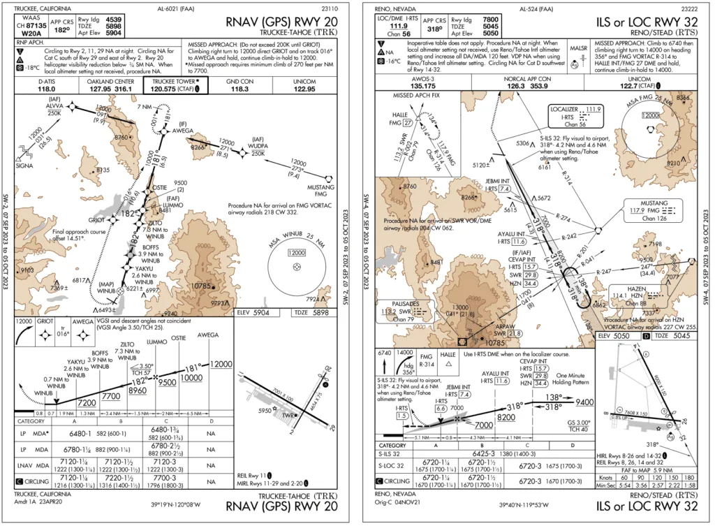
What does the snowflake symbol mean?
Below -18 degrees C, you must make cold temperature adjustments to some or all of the altitudes on this approach. It’s a surprisingly nuanced topic, but suffice it to say that you’ll be consulting the Cold Temperature Restricted Airports NOTAM for the rules, as well as the segments on which corrections are required, and the amount of the corrections. You’ll also be really cold. Luckily, some GPS navigators, like the GTN series, can make cold temperature adjustments for you … if you know how to tell them to do so.
KRTS ILS RWY 32
How many turns did you make in the hold at CEVAP?
ATC expects you to just use it as a course reversal, but that would be a pretty aggressive descent before immediately transitioning to the approach. You could ask for a second turn around the hold if needed. You could also look at the profile view of an approach and see you could get lower over most of this route and still have 2000 feet of clearance. A request to ATC might be approved when you crossed into a lower MVA.
DA on this ILS is over four NM from the threshold, yet the visibility minimum is only three SM. Could you actually get in if the weather was at minimums?
As a matter of fact, yes. This approach has the unusual fly visual segment shown with the dashed line in the profile view. When you reach DA you follow the instructions (under the graphic missed on this chart). “Fly visual to airport, 318° – 4.2 NM …” So you’ll fly for over 1.5 NM before the airport comes into view with 3 SM visibility, continuing to descend for the runway.
But what would you do if you had to go missed? Climb really hard to join the missed and hope for the best. Tip: Don’t follow the visual segment if there’s real doubt you can find the airport and land.
If visibility was less than three SM, would it make sense to use the LOC version since it has lower minimums?
Maybe. You’ll get closer but you’ll be way too high to land. Lucky for you the circling mins are the same as the Localizer mins. You’d be in a high pattern, but you might be able to descend close to the airport and land.


