Fall conjures memories of bright blue skies, cool mornings and generally good daytime flying. But in aviation, looks can be deceiving. New air masses are on the move, the jet stream begins to flex its muscle over much of the United States, fronts are marching southward, and there’s likely a tropical storm in the Caribbean or the Gulf. How does this affect your flying and how can you avoid an unplanned turn of events?
FAT Is for Fog
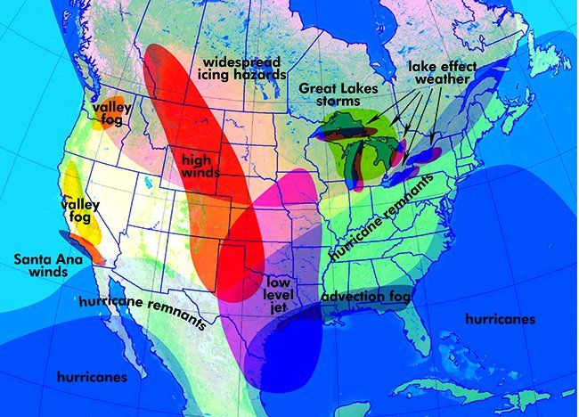
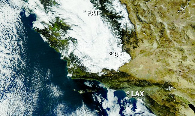
Fog makes a prominent appearance in the fall, and it can be serious. We’re talking about heavy fog, actual IMC, and an AOPA Air Safety Foundation study in 2010 found that two-thirds of IMC accidents are fatal. The biggest fog problem during the fall months is valley fog in the western United States—particularly the San Joaquin Valley of central California and the Columbia Basin east of the Washington Cascades.
California’s version is known as tule fog, and it’s implicated every few years in multi-car pileups, one of which involved 126 vehicles in November 2007. The fog hits Fresno, Bakersfield, Stockton, and Sacramento particularly hard, and will often take the airports well below minimums during the morning hours. Afternoon conditions improve to only a couple of miles visibility and 500-foot ceilings. Once it’s dark, things get worse again and the cycle can repeat for days.

Valley fog sets in when moist Pacific air and rain moves inland, followed by a night of clear skies and strong radiation cooling. Once developed, this fog can decouple from the air mass above, and remain in place for days or weeks. It may burn off during the day around the valley’s edges, but tends to rebuild at night. The fog is finally evicted when a Pacific system or some other major pattern change reaches the valleys.
When planning a flight to these valleys, be alert when a cool, rainy Pacific front is expected to move across the area, since this stubborn fog may develop the next night. Good alternates will be found at airports in relatively exposed, higher terrain.
Along the Gulf Coast, advection fog spreading inland from the coast often becomes a problem in the fall, even catching forecasters by surprise. It occurs west of high-pressure areas when a cold-air mass is replaced overnight by a southerly flow of warm, rich air from the Gulf. This causes broad areas of stratus and advection fog as humid Gulf air flows northward across the cool landmass, quickly bringing IMC to locations like Houston and New Orleans during the wee hours of the morning.
Since the fog closely matches ground temperature, it typically doesn’t show up on satellite images. It’s difficult even for forecasters to find until ASOS sites begin detecting it. Because of this, there will be some uncertainty in the overnight TAFs.
When flying at night near the Gulf Coast in light southerly flow, keep an eye on observations and watch for unexpected changes. Your best alternates will be found to the north, in the drier air away from the coast.
Finally, as large weather systems march across the United States, garden-variety radiation fog can set in anywhere there is a combination of wet ground, clear nighttime conditions and light winds. Daytime rain followed by nighttime clearing is all it takes.
Fortunately this radiation fog is quick to lift. While there is no good rule of thumb for an alternate, beefing up your fuel reserve will ensure you can safely get to another airfield if your destination goes below minimums. By mid-morning most airfields will already see substantial improvement.
HVR Is for High Winds
With the jet stream interacting more strongly with surface systems, high winds can be expected in and around surface lows, particularly those crossing the Rocky Mountains. Here, you can encounter some of the roughest rides of your life. The southern and southwest quadrants of these lows particularly favor high winds from the higher instability and interactions with cold air trapped in the intermountain valleys. Look for the strongest winds near and just downstream from mountain passes perpendicular to the wind flow. Rotors and turbulence are also likely downstream from mountain ranges.
Even if the storms leave the mountains and move into the Great Plains, the southern quadrant of deep surface lows retains the potential for potent high winds. This is because of the higher instability in this part of the system and a tendency for strong upper level winds to couple with strong surface winds.
Also, if the area has been under a drought, winds can loft vast amounts of dust thousands of feet into the air over a wide area, sometimes all the way from west Texas into the Dallas and Oklahoma City area. This is most likely during the afternoon, but by evening the dust will settle with VMC conditions returning.
Santa Ana winds are a different wind event that occurs in southern California whenever a strong high-pressure area builds over Nevada. This is most common in December but occurs any time during fall or winter.
Santa Anas drive desert air southwestward over the coastal mountains. High winds are concentrated within and downstream from mountain passes and will affect many airports in southern California. Depending on the temperature of the air mass, the Santa Ana wind emerges to the lee of the mountains as either a cold foehn wind or a warm chinook wind. Because of very low relative humidity and gusty winds, warm Santa Anas are associated with wildfires and the smoke plumes can quickly create large areas of occasionally dense IMC.
HWO Is for Hurricanes
Autumn is prime hurricane season, and a visit to the National Hurricane Center website is a good idea when you’re planning a flight into Florida, the Gulf of Mexico or the Caribbean. Although few pilots will fly into hurricanes, the remnants of a landfalling hurricane often move hundreds of miles inland into the eastern United States and can impact all types of flying operations.
Fortunately the dangerous winds are eliminated by friction within a day or two, but the core of the tropical system can carry astonishing amounts of water and bands of heavy showers and thunderstorms into places like Arkansas and Ohio, along with the potential for severe icing above 10-15,000 feet. At the ground, most airports under a hurricane’s remains are normally IMC until it passes. So even with remnants and weak winds, consider postponing that planned flight for a day until the system passes.
Remains of Pacific hurricanes spreading inland from Baja California are often overlooked. These remains spread northeast into Arizona, New Mexico, and Texas, and have traditionally been poorly handled by computer models due to the sparsity of observed data in Mexico.
As with Atlantic hurricanes, these can carry vast amounts of moisture and convection inland, even after crossing the mountains of Mexico. As with landfalling Atlantic hurricanes, pilots should expect IMC and extensive showers in places like Tucson, El Paso, and Midland as these remnants pass through.
ISN Is for Ice
Although winter typically doesn’t dig into the southern United States until December, pilots in northern states experience winter weather as early as October. It’s back to basics: understanding the different types of winter precipitation and how they occur. This is also the foundation for understanding icing, which becomes more of a factor with lower freezing levels during the fall. Knowing what kind of ice and weather is likely requires knowing three things: the temperature in the cloud layer, the cloud type, and the temperatures between the cloud layer and the surface.
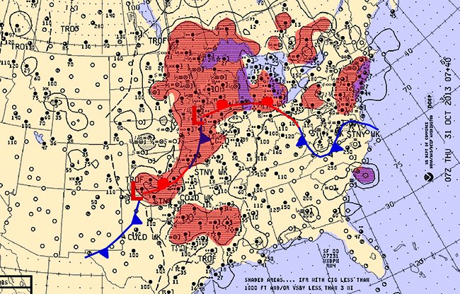
Perhaps we have too many traumatic memories of flight school and in our amnesia we remember only grade school science, where if it’s above freezing we get rain, and if it’s below freezing, we get snow. Unfortunately, it’s just not that simple. The problem here is that water can condense and remain in the liquid state well below freezing—a form known as supercooled water.
At temperatures of zero degrees C to -10 degrees C, supercooled drops are common. They are relatively warm and take time to freeze on aircraft surfaces, especially if they are warm or large drops.
Large drops are more likely caused by cumuliform clouds. This forms the dangerous clear ice. At colder temperatures of -10 to -20, the supercooled droplets—typically from stratiform clouds—are smaller and freeze more quickly. This tends to form rime ice. At temperatures of about -15 degrees C or colder, the cloud layer is increasingly more likely to produce ice crystals, which is essentially snow, and with increasingly colder temperatures the layer is almost entirely ice crystals with little or no potential for airframe icing.
Although it may seem like the best solution is to always descend below the freezing level to escape the ice, there are frequently weather situations where a warm layer is sandwiched between cold layers above and below. This is a textbook pattern found north of warm fronts.
Flying through the lower cold layer, you may encounter melted precipitation from much higher altitudes falling into the cold layer and freezing onto the airplane’s surface in the form of clear ice. The solution here is to either get the plane on the ground or immediately climb into the warm layer. Knowing exactly where these warm and cold layers are before you take off will give you a plan in case the icing gets out of your comfort zone.
LFK Is for Low Level Jets
As the jet stream becomes active across the central United States, the low level jet becomes a prominent part of the weather pattern in Texas, Oklahoma, and adjoining states. The jet stream is a nocturnal band of strong winds, typically 1000-4000 feet above the ground, and it flows from the south to the north from the Gulf of Mexico. Wind speeds in the low-level jet commonly exceed 50 knots, and since the jet is usually decoupled from low-level air during the early morning hours, low-level wind shear may exist in a shallow layer a few hundred feet above the ground.
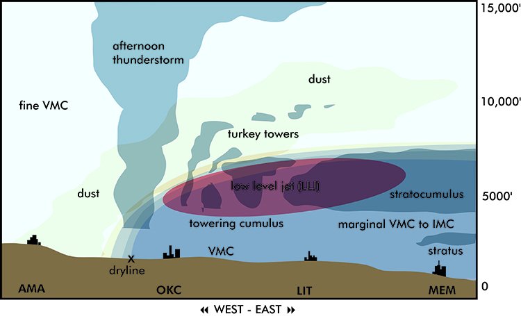
Since the low-level jet is associated with rich tropical air from the Gulf of Mexico, it produces extensive areas of IMC during the morning, usually in the form of stratus ceilings. Unless a front is located south of the airport, this fog and stratus normally lifts by late morning, resulting in improvement to VMC with cumulus and stratocumulus ceilings.
SAW Is for Surprise Storms
The Great Lakes are a special case because these are large bodies of water that remain relatively warm in spite of atmospheric cooling. This provides two essential ingredients for bad weather: heat and moisture. Just the presence of a front across the Great Lakes during the fall means that pilots should watch for ceilings or visibility to rapidly drop.
Well-developed frontal systems heading for the Great Lakes are an even more serious matter, since the heat and moisture feeds the storm and can cause rapid development. A classic example is the storm system of November 10, 1975. In just 24 hours, a low pressure area over Kansas with an altimeter setting of 29.52 at its center moved almost 1000 miles to Lake Superior, where the pressure dropped to 29.02. The powerful winds resulted in the sinking of the 700-foot SS Edmund Fitzgerald (as in the Gordon Lightfoot ballad) with the loss of all 29 aboard. Almost all aircraft except those in Class A airspace would have encountered extensive layers of clear icing.
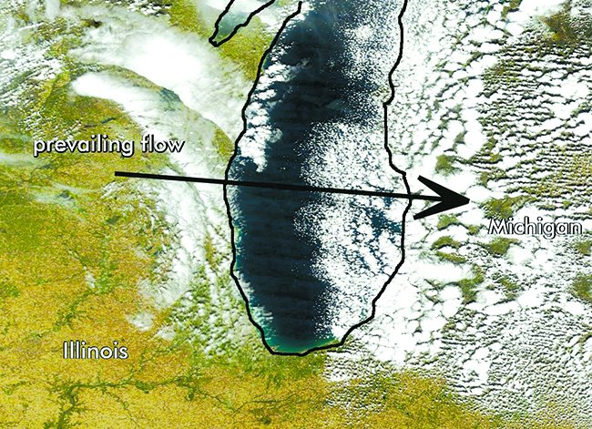
The warm lake waters also result in lake-effect weather as cold air masses move across the lake and become saturated with moisture. This produces clouds and precipitation where the lake wind comes ashore, with cloud layers extending 50-100 miles inland. This type of weather is not particularly dangerous, and with the air mass being unstable the result is cumuliform clouds, intense showery precipitation, and good visibility outside the rain or snow showers. Instrument conditions can be persistent at cities such as Buffalo and Erie, but problem areas are localized, and good alternates can be found a short distance inland.
Final Thoughts
Autumn weather changes need not be feared, but the changes in the atmosphere heading into the cool season are indeed profound from a meteorological perspective. Fortunately aviation meteorology is an 80-year old profession and forecasters are well versed in all the hazards the season brings. Careful flight planning and checking the TAF, SIGMET, and AIRMET products almost always assures an uneventful flight. Unfortunately the reality is that even the most sophisticated meteorological models are still an approximation, and TAF amendments are a fact of life. So preparing for the unexpected not only makes good sense but is extra insurance for getting you and your passengers safely to your destination.
Tim Vasquez is a professional meteorologist in Palestine, Texas. See his website at www.weathergraphics.com.

