Flying brings pilots into all kinds of unexpected meteorological hazards. Normally we present you with introductory articles about these topics so you can understand what they are, where they occur, and how they work. But sometimes presenting an actual case study from NTSB reports really drives the point home. We see the hazard vividly from the perspective of those who faced this same sort of trouble. We can see actual data reconstructed from that day, challenging us to ask questions for, hopefully, a safer outcome for ourselves.
To illustrate: You’ve probably forgotten the fog information we went over in May 2013, but many of us have pored through pages about the events that took place on a foggy runway in Tenerife in 1977, and pondered what we might have done in the same situation. We tend to not forget this kind of information very easily. So this month, we turn to the NTSB archives, special data collections, and my own expertise to study the mistakes and oversights that led to weather-related tragedies. Our goal is to recreate the event, discuss the underlying weather, and find the lessons that can be learned.
A Rainy Day in Georgia
Our first case study starts out in Tuskegee, Alabama. It was early July and a husband and wife, aged 55 and 61, respectively, had spent a week-long trip in the area with their two grandchildren, both 10 years old. A coworker remembered, “They’d take off and just fly everywhere, just to go eat. They loved flying.” The Piper PA-23 twin-engine airplane belonged to the wife, but only the husband held a current license.

They had planned to take off around 1 p.m. for their flight to Athens, Tennessee in the eastern part of the state. The afternoon was hot, with a temperature of 91 degrees. The dewpoints were reaching sultry levels even for summer. This by itself signified great potential for afternoon storms.
Unfortunately when the couple arrived on the ramp, they found that the battery in their airplane was dead. The plane had to be towed to a hangar to be fixed, so the family went to a restaurant to pass the time. The recharge worked, and the flight finally took off around 3:45 p.m. According to the FAA, the trip was strictly VFR and no contact was made with any flight services during its journey to Athens, 190 NM and about an hour and a half away.
The first half of the trip was pleasant, marked by the passage of scattered cumulus clouds at 4000 feet and clear blue skies, but the horizon darkened to the north and their flight took them toward a cluster of thunderstorms. For reasons unknown, the pilot decided to penetrate the storms.
Along Piney Hill Road, about 4 miles southeast of Chatsworth, Georgia, skies were darkening, rain was starting to come down, and lightning strikes were hitting the ground. A fresh breeze from the storms stirred the trees. Then residents along the road reported hearing a loud boom. A woman looked outside and told reporters she “saw stuff raining from the clouds.” Once police were on scene, they found wreckage along a mile-long swath toward the northeast. The crash had claimed the lives of all four occupants.
The NTSB investigation team analyzed the wreckage, pored through weather data, looked at maintenance data, and consulted with controllers. It was determined that the airplane had broken up in mid-air after flying into a thunderstorm. Fuselage fragments were first along the track to hit the ground, followed by wing assemblies, then the engines. Very little of the airframe was intact.
The pilot did not hold an instrument rating and was overdue for a medical exam. A forum post a few months before the accident showed the pilot asking questions about upgrading a Garmin GNS 530 display to WAAS, but the NTSB has not yet released the final report, which indicates the exact equipment on board.
Yes, Weather Was the Culprit
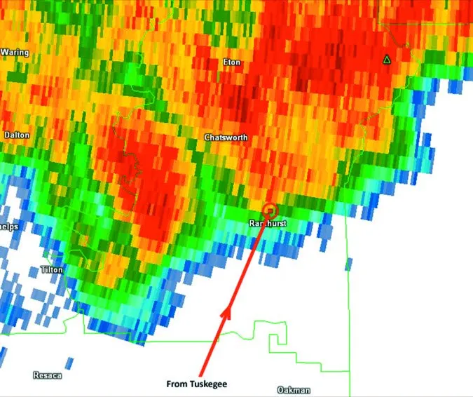
Using high-resolution raw radar data, we can obtain a much more detailed picture of what happened. ARSR radar tracks combined with NEXRAD weather data showed the airplane broke up before even entering the characteristic yellow (40 dBZ) bands, which are typically associated with heavy rain. This 40 dBZ intensity is typical of garden-variety summer thunderstorms, so what happened?
It’s important to remember that radar imagery strictly depicts precipitation that is in the cell. Radar does not detect the cumulonimbus cloud itself, nor does it detect the updraft. This is a distinction that is often not understood or is overlooked.
Analyzing the atmospheric shear profile showed that precipitation was being deposited to the northeast of the mean wind. This produced east-west gust fronts that favored new cumulonimbus growth on the south sides of the storms, where 10-15 knot low-level winds were feeding northward. In other words, we are likely to find cumulonimbus towers and updrafts south of where we find the downdrafts and radar signatures. Thus the airplane had likely entered a thunderstorm updraft first, and was torn apart by strong turbulence, caused in turn by high vertical velocity and shear in the storm updraft.
Data suggests that the updraft might have been around 4800 fpm. Of course, it’s not velocity that chews up airplanes, but shear that’s responsible for most thunderstorm accidents. When we fly into this shear, we feel it as turbulence.
Plus, the updraft rarely ascends uniformly. Rather, it often ascends as a plume or a pulse, and horizontal shear around the edges of the updraft can roll up vortices. All of these irregular structures can amplify and concentrate the shear unpredictably—on the scale of seconds and tens of meters.
Visible satellite imagery showed widespread scattered cumulus in northeast Georgia, so there is almost no question the pilot was aware of the thunderstorm activity. The storms straddled the route to Athens, suggesting the pilot planned to punch through the line, further suggesting he underestimated the storm activity, was overconfident, or simply ignorant of thunderstorm avoidance guidelines. (See the FAA’s AC00-24C, Thunderstorms)
It’s conceivable that these storms could have been penetrated safely using on-board strikefinder or weather radar, or at least relying on ATC’s weather radar overlays. But, on-board data feeds should never be used to thread the needle, due to latency and vertical sampling issues. Of course, avoiding the storm altogether is the safest option; had the pilot flown north to Tennessee then turned east, we wouldn’t be studying him. He simply needed to have checked the route weather before takeoff.
Clipper 759 Down in Kenner
The next accident also occurred in thunderstorms. On July 9, 1982, Pan Am Flight 759, a Boeing 727-200, pushed back from the gate for Las Vegas. In the cockpit were 45-year-old captain Ken McCullers, described as “conscientious” and “strong in knowledge of procedure;” first-officer Donald Pierce, 32; and flight engineer Leo Noone, 60. The 727 was very heavy with fuel for the three-hour flight, almost at maximum takeoff weight. A cluster of thunderstorms was north and east of the airport, and as the airplane began its taxi, the CVR recorded the windshield-wiper noise.
Midway during the taxi, the tower reported winds had picked up to 07017G23KT. The controller notified the Pan Am flight of a wind shear alert north of the airfield but not on the flight’s runway. The captain, concerned about weight and the wind shear alert, told the first officer to turn off all the air conditioning packs and “let your airspeed build up on takeoff.” He also went over a plan to dodge some cells further to the southeast.
Just after 4:06 p.m., Flight 759 lined up on Runway 10 and was cleared for takeoff. After slowly bringing the engines up to takeoff power, they released the brakes. Witnesses, including tower personnel, said the airplane’s configuration and attitude looked normal, but the plane never gained more than 100 to 150 feet of altitude.
A flight-data specialist in the tower watched the takeoff, saying, “I observed the airplane climb in a normal manner until it reached an altitude of about my eye level [126 feet] at which time I turned away.” The airplane continued about 3/4ths of a mile, sinking and hitting trees. Here, eyewitness reports diverged, reporting an attitude anywhere from a “slight pitch-up” to 45 degrees nose up, with about an eight to nine degree consensus. The plane crashed into a residential area and disintegrated into a fireball. There were no survivors.
Given the limited understanding of microbursts at the time, the NTSB investigation found no fault with the aircrew, the controllers, or the airline. The report concluded that the main problem was the limited capability of the existing wind shear detection technology, and it urged further development of technology, better avoidance training, and more PIREPs from wind shear encounters.
Uncovering the Microburst
The microburst is a type of thunderstorm downdraft defined by its intensity and scale. The existing technical definitions specify a size under 2.5 miles with a velocity difference of 20 knots or more. This is an unusually small, compact volume of dense air descending in the thunderstorm downdraft. In the cockpit, sudden changes of 15 knots airspeed, 500 fpm vertical speed, or five degrees of pitch are indicative of a wind shear encounter. The mechanisms that produce microbursts are still not well understood, but forecasters can often identify the environments that favor them.
Some microburst accidents are caused by the downdraft vertical velocity exceeding the airplane’s power and climb capabilities. However, most are caused by winds suddenly shearing to a tailwind while the airplane is at low speed, sometimes with reduced power settings (for landing), causing a stall or an uncontrolled descent.
The small scale of the microburst is important because it causes very rapid airspeed transitions which exceed the ability of crews to react. Exact procedures to take depend on the aircraft you fly. What works in the 737 isn’t what’s recommended in the Cessna 172, so we’ll refer you to your manuals and training. However, this article at least gives you some understanding of microbursts and where you might encounter them.
Flight 759 remains to this day the worst weather accident in the U.S. It underscored the danger of microbursts around major airports and helped bring them into the public conscience, during a time when lightning—not wind—was perceived as the danger. The government had already acted following the wind-shear-induced crash of Eastern Flight 66 in 1975, rolling out the Low Level Wind Shear Alert System (LLWSAS) two years later.
Ironically this LLWSAS system was operational at New Orleans and identified wind shear at the airfield but not on Clipper 759’s runway until after it departed. Though technological solutions were available, the NTSB found that flight crews still didn’t fully understand the wind shear problem. For example many pilots were not aware that they could request spot wind readings along the runway from this alert system. Simulator training of the era was thought by the NTSB to be oversimplified, instilling a false sense of confidence. Plus, the LLWSAS system wasn’t trusted; Pan Am’s own manuals said the warnings were to be used for “informational purposes only.”
From a forecaster’s perspective, the storms in New Orleans were nothing particularly unusual; they were textbook summertime subtropical thunderstorms. They were not strong enough to warrant any weather warnings, though wind gusts at the airport ultimately peaked at 30 knots later in the hour as new cells built over the airport.
The case of New Orleans is interesting, as microburst winds are most common in “hot and high” areas of the United States. A 2007 paper by James C. Walter of the Salt River Project established microburst climatology and found the highest incidence to be in the Desert Southwest, New Mexico and West Texas, with a second zone in the Dakotas and Minnesota.
However the paper found that microbursts occur regularly in all of the lower-48 states, even in places like Maine. This is still an area of ongoing research, however, as there is no existing database of microbursts and they must be inferred based on predictors most strongly linked with their occurrence.
Clearly, thunderstorms are a major flight hazard in the U.S. during the warm season. We’ve covered wind shear around the periphery of the storm, plus hazards from low-level wind shear phenomena like microbursts. Hopefully, your takeaway from these accidents is recognizing these hazards when they’re developing in front of you.
Tim Vasquez is a meteorologist in Palestine, Texas His followers included B-1B Lancer crews who regularly complimented him for looking out the window before giving them his forecast. See his website atweathergraphics.com.


