Remember that your IFR GPS, now standard equipment for all flavors of light aircraft, is usually a two-in-one navigator. Yep, it has more than the habit-forming GPS receiver displayed on a moving color map. Most units include a VOR/Localizer receiver, a page displaying a CDI (Course Deviation Indicator) needle, and is likely connected to a primary or secondary CDI as well. Maybe you also held onto an existing navcom with a CDI that still works. Even if you’re well versed in these features, they likely go unused. But don’t get rusty on that stuff yet.
Checking Boxes
My EFB has a neat feature that filters approaches at a selected airport by equipment level: “ALL”, “ILS Only”, “GPS Only”, “Six Pack.” Now, flying a basic six-pack C172 upgraded with a like-new, non-WAAS GPS, we can use LNAV mins, VOR, and localizer MDAs. The installation moved the older indicator and navcom to number two.
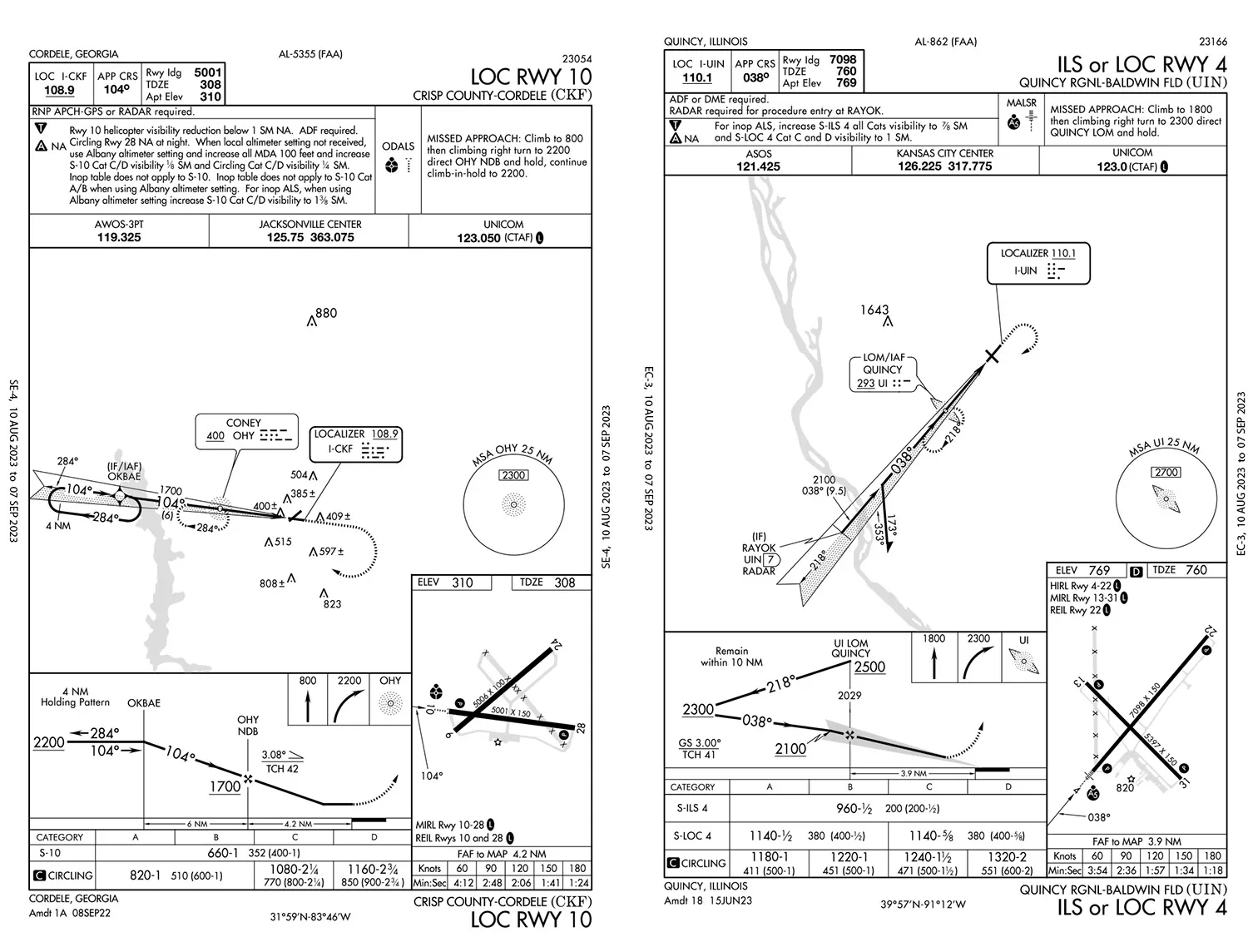
Our break-in flight is Lakeland, Florida, to Cordele, Georgia, to see the military and air museum west of town. Winds at KCKF will favor Runway 10, 5001 feet. So plan the RNAV 10. But with the overcast ceiling at 300 feet and touchdown zone elevation of 308, the LNAV MDA of 680 might not get you in. Meanwhile, the LOC 10 MDA goes to 660 feet—still tight, but the odds are better.
Look at the approach chart. Really look; don’t just see “LOC” in the title and stop there. Approaches based on ground-based navaids, like ILS, localizer, and VOR, now often incorporate RNAV elements. These’ll show up as equipment requirements in the Notes Box of the Middle Briefing Strip (official names; see the FAA Chart User’s Guide). This one says: “RNP APCH-GPS or RADAR required.” That’s for the IF/IAF, OKBAE, displayed on the planview as an RNAV waypoint.
Want to confirm the “RNP” for your GPS? First, check the aircraft Flight Manual Supplement that came with the new unit, which outlines specifications, privileges and limitations. Then refer to Advisory Circular 90-108, Use of Suitable Area Navigation (RNAV) Systems on Conventional Routes and Procedures. Here, see where and when you can legally use it, along with any signal integrity requirements like checking GPS NOTAMs.
What if the GPS went inop? The localizer plus radar services from Center are an alternative to confirm OKBAE, usually by just getting vectors to final with an intercept just inside OKBAE. This is a good backup, and it’s highly unlikely to have radar and GPS outages at the same time. Meanwhile, you file a route using airways VOR-to-VOR, Ocala to Valdosta to BLSKY (not shown). You track these with GPS or your VOR/LOC receiver, or both if you want more workload.
Here the third type of navaid emerges, buried in other fine print in the Notes Box: “ADF required.” That’s for the CONEY NDB that’s the FAF and missed holding fix. Any IFR GPS can be used in lieu of ADF to identify an NDB or the Compass Locator (simply a low-range NDB used as an ILS/LOC approach fix). So you’re good to go there.
Given the weather, you need an alternate with at least one available approach within fuel reserves. This will be Macon, Georgia, to the northeast. There’s an ILS/LOC 5 there, and it even lines up with the east winds. The RNAV 5 is also available for our equipment, which is good to know.
Say the localizer is out of service, and if you did the homework you know you can still file Macon as the alternate and expect the RNAV 5, because at Cordele you planned on the localizer.
For our non-WAAS TSO-C129 certified GPS, we can’t plan on GPS approaches at both the destination and alternate. So, this type of GPS is best used with a backup nav source—the VOR/LOC receiver ensemble—if the RNAV unit can’t fulfill accuracy requirements and we need different navigation. We also need to check the either/or rule so we don’t get stuck without a reachable alternate, at least for filing requirements, due to equipment limitations, weather, or fuel.
They’re Everywhere
Now, let’s head to Quincy, Illinois, to see another aviation museum. Quincy also has the six-pack catch. The ILS or LOC 04 at KUIN has a three-layer set of equipment requirements in the Notes: “ADF or DME required.” And: “RADAR required for procedure entry at RAYOK.”
Again, you may use radar for the whole thing, but you’ll need a conversation with ATC about what you need. And if you don’t have an IFR GPS you need ADF or DME. Again, any certified IFR GPS will be okay for identifying VORs and NDBs, and they are also fine to use in lieu of DME.
DME? We no longer use the full name, Distance Measuring Equipment, named after what they do when paired with a compatible ground station (VOR or LOC). They displayed distance to a VOR/DME or LOC/DME to the tenth-mile. But its line-of-sight measurement can be inaccurate at close distances.
It’s great to be past all that and enjoying GPS. It’s way more accurate for distance, time, and situational awareness, plus it can list all that data to each waypoint on your flight plan. Having said that, any remaining DME units out there are still handy as a supplemental display when using multiple navaids. So, you can use the GPS in lieu of VOR, NDB and DME for routes and approaches—three out of four types of ground navigation are allowed.
But AC 90-108 also says you can’t sub GPS for lateral guidance for either a ground-based navaid on the Final Approach Segment, or on localizers “without reference to raw LOC data.” That means truly using the VOR/LOC ensemble, or better yet the nav receiver in the GPS. And for the blissfully unaware who have not tuned in a localizer since forever: Try it. Don’t be shy; push the button that says “Nav” and tune one in, then switch navigation mode to VOR/LOC.
Springfield is a good backup, offering both localizer (yes, ADF required) and RNAV approaches for current conditions. Quincy’s LOC 4 MDA is 1140, also a tad lower than the LNAV’s 1160 feet. There are the notes requiring ADF or DME, and RADAR. This is an interesting one. The only initial fix is the Quincy Locator Outer Marker, so if you did want to fly yourself to the straight-in rather than vectors to final, you would need a “cleared direct RAYOK” to enter the approach. Even if you had DME or its GPS equivalent to confirm the seven miles to the localizer antenna, radar is still required and is repeated on the planview in the RAYOK label.
Yet another catch on this one: The “UIN 7” at RAYOK is for the localizer, not to be confused with UI, the identifier for the outer marker. And this is not a DME-based missed approach that provides a distance from the FAF or to the localizer on the other end to cue you in on the missed, but an MDA, hence the FAF-to-MAP timetable. This missed approach, like Cordele, calls for a hold at the NDB/outer marker. So if using GPS as an aid to the localizer approach, have QUINCY in the waypoint list for backup.
Why All the Fuss?
Making the most of your equipment is one thing; encounters with unfamiliar navaids can mean the difference between legally flying an approach or not, or at worst getting caught unaware on how to confirm an approach fix. At the very least, know how to use that secondary mode on your GPS. If you’re firmly entrenched in the IFR (I Fly RNAV) category, fine. There are plenty of airports with all types of procedures, and some with only RNAV approaches to each runway. But there are many more with combination procedures, some with strange-looking waypoints that are easy to mix up with others. Throw in low weather and alternate constrictions, and it’s best to avoid unnecessary limits to what you can do.


