General aviation cockpit tech has made amazing advances. New avionics commonly boast large screens and that easy-to-follow magenta line on the moving map with myriad other features. A 172 can navigate from takeoff to touchdown. The right software on an iPad can as well, for much less money. We no longer chase ADF needles, center VOR-tuned OBS needles, figure cross-wind corrections, mentally calculate distances, etc. Just follow the magenta line.
Advanced avionics have likely improved safety. A research study showed a decreased fatal accident rate for instrument private pilots in IMC over the 2002-2011 period, although improved training has also likely helped. Drawing on NASA research, I’ll focus on the downside of newer avionics as it relates to IFR flight and illustrate the point by a comparison of the Garmin GTN 750 with its prehistoric antecedent, the GNS 430.
Children of Magenta
Human factors geeks realized that automation dependency is a big downside to modern avionics. The airlines learned this early since new toys often came to them first. A 1997 American Airlines seminar appropriately titled “Children of Magenta” summed up the problem nicely, and is even more appropriate today.
Pilots were (and still are) over using automation, resulting in too much head-down button-pushing. The result was (is) an increase in situational awareness errors and loss-of-separation in particular. One flight crew got so absorbed entering a simple runway sidestep that they landed without a clearance. As the presenter advised, sometimes it’s better to reduce the level of automation for a given task. He summed it up nicely—we’re pilots, not automation managers; fly the plane first and keep up those manual skills.

Use ‘Em or Lose ‘Em
Fast forward to 2014 where NASA scientists published a study looking at how 747 pilots navigated to a VOR or a missed approach point (in a Level D simulator—those airline sims up on hydraulic stilts) with no moving map, autopilot, or flight director. Performance was dinged if they missed the waypoint by more than three NM, were more than 10 degrees from the assigned heading or more than 300 feet off altitude. Of 16 pilots, 16 percent busted the altitude assignments and nearly half mis-identified the missed approach fix. Three descended below the MDA and nearly 40 percent went the wrong way at the final approach fix and missed the airport! The conclusion, according to the authors, is that basic navigation skills are easily lost to cockpit automation. These weren’t rookies; they had on average 17,800 total time and 623 hours annually.
Tune-In, Drop Out
Another NASA study that year looked at the effects of automation on airline pilots’ task-related thoughts or, conversely, task-unrelated thoughts (tuning out). The pilots were asked to use automation to fly an arrival with altitude restrictions. With more automation, pilots’ mental thoughts were commonly related to future flight tasks—they were ahead of the airplane. But not all of that available mental time was devoted to flight-related thoughts; their minds wandered.
New and Improved but Better?
Is the same true for GA pilots? It seems that there’s somebody always releasing something new with great fanfare plugging the advances. Google any avionics product and you’ll find endless discussions and videos touting all the benefits of the new device. The aviation press does its part too, gushing about new products with nary a criticism. Call me a cynical scientist, but I have to ask if it’s just new, or if it is indeed better.
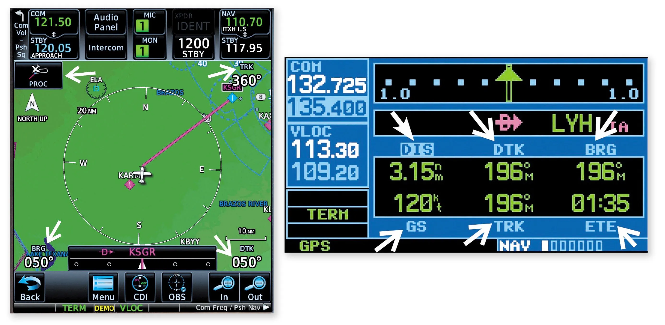
Let’s do an IFR-operations comparison of Garmin’s GTN 750 (continually improved and updated since its 2011 introduction) and the GNS430 (introduced in 1998). The GTN 750 boasts a large moving map while the GNS 430 defaults to a nav page with six data fields. According to Garmin, you’ll be “tapping into the future of avionics” with the GTN 750’s touchscreen and cockpit connectivity to keep “your tablets and portables in sync.” Of course, the marketing hype goes on.
To me, the GTN 750 trumps the GNS 430 in that the menu-driven graphical interface is easier to learn and might be better for the infrequent pilot. But, although easier, some tasks will take more time to accomplish. One can get deep into sub-menus to access a single task. Say you have an emergency and need to land. Locating the nearest airport is three clicks and less than a second with the GNS 430. The GTN 750 requires locating and pushing three buttons on three successive screens. The lack of an explicit procedure button on the GTN 750 is another example of more steps. I’ll concede that nothing is especially difficult on the GTN 750, but it often requires more actions that take longer.
If the GTN 750 is controlling an embedded audio panel there are a maximum of four data fields available and they’re on the map page, compared to six on a dedicated page in the GNS 430. Before you tell me that nobody needs that data with a moving map, recall the NASA research and the American Airlines experience. Tune out mentally by blissfully following the magenta line and you could get yourself in trouble. If airline pilots flying daily can get behind the airplane, the general aviation weekend warrior almost certainly will as shown by the NASA research.
Remaining engaged in the flight is important and data helps by making you think and interpret it. For me, having readouts of distance, track (trk), desired track (DTK) and time to waypoint keeps my brain spooled up. In the plane I fly, I use both an installed GTN 750 and GNS 430 to display the data I need.
Wrapping Up
It’s human nature for us to choose the path of least resistance when choosing how to proceed. That’s just as true in aviation—it’s easy to succumb to the allure of the magenta line. Still, as the research shows, it’s well worth keeping your brain engaged in flight-related tasks rather than listening to the Beatles on your Sirius music subscription. Keeping the mental gyros spooled up might well make the difference between a successful and unsuccessful flight one day.
Garbage In, Garbage Out

Overreliance on automation isn’t new. In 1979 Air New Zealand operated a sightseeing aerial tour of Antarctica. State-of-the art avionics then included an Area Inertial Navigation System (AINS) displaying waypoints and the corresponding distance. VOR/DME nav equipment was also standard for receiving the ground-based navaid located at the bottom of the world. Flights were under positive control with a radar-equipped en-route facility (Mac Center) and an aptly named “Ice Tower.”
It was a round-robin flight from Auckland, providing a scenic view from 2000 feet of McMurdo Sound, 27 miles west of Mt. Erebus on Ross Island. Unknown to the DC10 crew, during the previous night the Air New Zealand navigation department moved the most southerly waypoint 27 miles east, to the TACAN, with the consequence of creating a route smack over Mt. Erebus.
On the fateful day the flight crew blissfully followed their programmed AINS. Some 50 miles north of McMurdo, communications with Mac Center by VHF proved difficult and the flight crew was unable to receive the TACAN (not surprising as Mt. Erebus was blocking line-of-sight communications/navigation). Nevertheless, the flight advised Mac Center that it would proceed visually to McMurdo and descended to 2000 feet in VMC. The aircraft slammed into Mt. Erebus with the loss of all onboard eight minutes later.
Of course the navigation department was partly to blame by changing the route without notifying the crew. But the flight crew was over-confident of their position via a single navigational source. Some other cues were also ignored. Remember pilots should avail themselves of all available information/equipment, including the pilots’ eyes. Beaufort Island (photographed by a passenger and presumably seen by the flight crew) should have been to the left of the intended route rather than to the right as in the actual track, thus providing a clue that the plane was off course. Degraded VHF communications and TACAN navigation, both dependent on line-of-sight, should have also provided a hint that indeed something was amiss.
Douglas Boyd Ph.D., a nerdy research scientist and active commercial (SMEL) instrument pilot, prefers navigating by the numbers instead of the magenta line.


