Sim to Match My Panel
Your article on simulators probably saved me $20k for a BATD that is nothing like the panel on my aircraft. I’m looking into building my own with an identical panel. But I barely know anything. Was hoping you might kindly point a noob in the right direction. Many thanks,
—Nick Kulkarni, Spring Lake, Michigan
Depending on the panel you’re looking to emulate, we can recommend RealSimGear. They will custom build a simulator to your specifications, but are largely limited to the components they sell. You might also check with XForcePC, but in the past we’ve found their willingness to custom build a ready-to-use sim is limited, focusing more on a framework of hardware and software from which you can build your panel.
Also, as explained in our multi-part series on building your own sim, lacking a great deal of personal technical work to customize, program, and build the parts and pieces, you can usually get somewhat close, but not identical to your panel. If you’re willing to go all touchscreen and use Air Manager, you can get much closer than if you want physical components.
Air Manager, from Sim Innovations, allows you to custom build an instrument panel layout from libraries of completed panels and individual instruments. It’s only slightly more difficult than drag and drop. But, it also allows you to completely customize or even build instruments from scratch if you’re willing to delve into the programming. The library instruments in Air Manager are variously compatible with X-Plane, MSFS2020, MSFSX, and/or Prepar3D.
RWY 2, Not RWY 02
In the January Chart Clinic you mention Runway 02. It should be RWY 2. There is no leading zero on runways in the U.S. system. In fact, the airport sketch clearly shows Runway 2, not 02.
ATC will also never say “02” with reference to that runway, and I’m sure the paint marking is 2, not 02.
—Barry McCollom, Kerrville, Texas
Yeah, but… This is not completely correct either: It is common on NOTAMs to put a leading zero on single-digit runway numbers to reduce possible confusion:
RWY 36 CLSD…
…RWY 02 FST 1000FT CLSD…
RWY 09/27 CLSD EXC ACFT MORE THAN 13500LB…
Also in the US Terminal Procedures Publication for KBAF, leading zeros are included in the procedure name:
ILS OR LOC RWY 20
RNAV (GPS) RWY 02
RNAV (GPS) RWY 20
VOR RWY 20
VOR OR TACAN RWY 02
Finally, note that a leading zero is common in other ICAO countries. But, you’re right in saying that in the U.S. neither ATC nor runway markings use the leading zero.
Good Enough?
Enjoyed your article, “False Glideslopes.” It was an education for me. I’ve been caught often by false LOC signals but not by glideslope (yet).
In the sidebar you mentioned that the FAA considered eliminating ILS some time ago but dropped the idea (for redundancy). True, but I gather another reason was that even with WAAS, GBAS cannot provide the lateral accuracy required of CAT II and III approaches.
—Douglas Boyd, Sugar Land, Texas
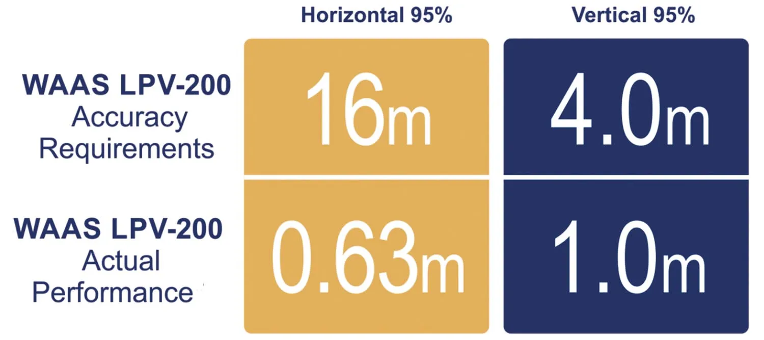
You bring up an interesting point, Douglas. From the FAA: “The FAA [defines] systems to sustain Category-I ILSes at selected sites and to sustain and establish Category-II/III ILSes where needed. As the FAA transitions to PBN, ILS systems will continue to provide GPS-independent Category-I/II/III vertically guided approach services. ILS is the only system currently approved for Category II/III operations. Last updated: Monday, December 04, 2023.” (Emphasis added)
The image is also from the FAA. While not approved for CAT II, the demonstrated accuracy appears it could meet CAT II requirements (if separated from CAT III). The vertical accuracy would require additional work for CAT IIIC. The confidence level for ILS accuracy is 99.9 percent. ILS CAT II & III design requirements for “vertical accuracy are 1.2 – 0.6 m.”
Interestingly, years ago I worked with a Honeywell engineer who did the “pioneering” work on local area augmentation for GPS approaches. I might have told you the story before, but they installed it at EWR, Houston and some in Europe. They kept getting crazy inconsistent results at EWR. Interstate 95 runs next to the airport, and they found that some truckers had outfitted their rigs with GPS jammers so that the boss couldn’t keep track of them! The jammers played havoc with the GILS. With the implementation of WASS, the LAA effort evaporated at Honeywell.
—Bob Teter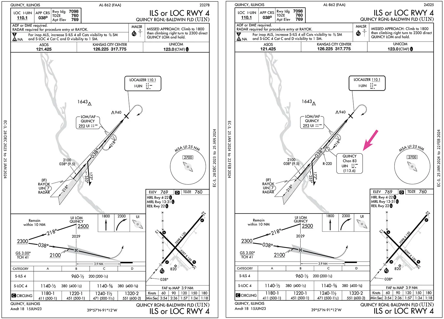
Why Where?
Your response to a reader’s question entitled “Why There?“ about the ILS 4 approach at KUIN in the February 2024 Readback explained the situation well.
But I pulled up the approach chart and got confused. You wondered why the UIN TACAN isn’t depicted on the approach chart, but it was there. The new 25 JAN 2024 revision of the chart now shows the UIN TACAN. I’m impressed with the influence you wield
As an aside, what is the (9.5) just inside RAYOK for? Is it the distance from RAYOK to the LOM? Also, depicting the 220 radial off UIN seems pointless due to such an acute angle.
—Frank Arrison, Doylestown, Pennsylvania
We wish we had that kind of influence, but it was just good timing.
And, yes, that 9.5 is the distance from RAYOK to the LOM. The R-220 is depicted to clarify that RAYOK can be identified on the localizer at seven DME on R-220 from UIN. Yeah, it’s kinda cluttered, which might be why they removed it in the first place.
We read ’em all and try to answer most e-mail, but it can take a month or more. Please be sure to include your full name and location. Contact us at Frank@IFR-Magazine.com.