Your last flight was 13 months ago, the coronavirus having curtailed your flying activities. Safely vaccinated, you’re itching to get back in the air but there are no instructors available where you normally fly at your home ‘drome. Instead, you have booked a few lessons with a new instructor quite a distance away at Van Nuys, CA (KVNY), an airport you’ve not seen in several years.
The FBO has some rentals to choose from … but, like you, they haven’t flown very much recently either. Your first two lessons are in a Cessna 172RG and you’re able to knock off some rust with takeoffs and landings and some air work. You feel good about getting some sky time and, anticipating a chance to make some of those COVID-delayed aerial outings with the family, you want to get some practice in actual instrument conditions.
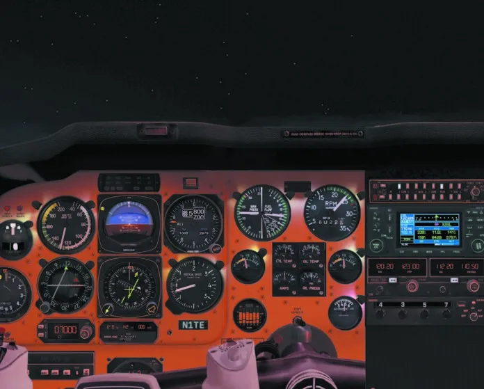
After a short delay, your schedule and the desired weather conditions finally come together. The overcast ceilings are variable between 700-800 feet, there’s good visibility, and westerly winds at 15-20 knots. Tops are reported at 7000 feet. Today’s aircraft is a Piper Arrow, sporting a Frankenpanel with an interesting mix of analog and glass.
You review the power settings required for various phases of flight and your instructor tells you to expect some air work northwest of VNY followed by an ILS. After the ILS, you will try an RNAV approach. During your weather briefing you see a NOTAM that the approach lighting system for Runway 16R at Van Nuys is out of service, but the instructor interrupts as you begin to consider what that might mean.
The takeoff and climb into the practice area go well. You work on some climbs, turns, and descents. You want some practice with the autopilot but even after two or three attempts at engaging it, it doesn’t seem to work. Your instructor tries but has no better luck. He continues to fiddle with it as you check the circuit breaker panel and find no obvious fix. After some more air work east of the Filmore VOR (FIM), you are ready to try an approach.
Your instructor is getting a new ATIS and still busy working on the autopilot issue. He says to plan on the ILS Y 16R. You decide to request the ILS Z 16R as the new ATIS is reporting 500 OVC. SOCAL approach assigns a heading to join the 053-degree radial from FIM and then clears you for the ILS Z to 16R at 6000 feet.
As the pace quickens, more of the rust from your pandemic enforced rest from flying is becoming obvious. Can you make this work?


should i be able to find the relevant approach plates somewhere?
skyvector.com, airnav.com or the FAA’s digital terminal procedures site. There’s many, many options for viewing charts online.
Being Vaccinated could have been left out of this article. No need to imply your personal health beliefs in an article that doesn’t require them. That is a decision each reader can make on their own and isn’t required to bust the rust off.
Selfish is good for nothing.
The instruments should be larger and more visible
It wasn’t immediately apparent that I was supposed to refer to the panel image for question 1, but even so, the answer to the question would be 11.8nm from Asheville Regional in North Carolina, according to the GPS. Also, none of the NAV frequencies are appropriately configured for this approach. I was doomed to get this question wrong.
100%. I can only imagine they dropped in the wrong graphic for the article.
Leave your social sensitivity at the door when it comes to scenario based discussions and as a good instrument pilot focus on scan sensitivity. It would help if we had correct navigational info depicted.
The only information available for question 1 says you are east of the Fillmore VOR. How are you supposed to know whether you are east or west of the localiser since the Nav frequency selected is not the one for KVNY ??
You’re not losing your mind. The picture is from another scenario. Look at the GPS 🙂
I assume the picture of the panel is a mistake but even so…
You can answer every question except #1 by reference to the approach plate (from foreflight or fltplan.com) and the FAR/AIM.
If anyone figured out how to answer #1, Id love to hear it since I cant find any of the frequencies dialed in to the Nav radios on the approach plate or the low-IFR chart for the VNY area