In most of the world, a shiny, new RNAV approach that lowers minimums by 500 feet is cause for celebration. Not so at Anaktuvuk Pass, Alaska. At least that’s what one Alaskan pilot and IFR reader tells me. Our phone call puzzling out a potential solution revealed limitations of cockpit tech, the practicality of old-school scud running, and a potential remedy by blending the two.
Anaktuvuk Pass airport is a gravel strip serving a village of about 300 people. The only way in is by snow machine or aircraft. There’s an NDB on the field that both served as the only approach navaid, and the terminus of airway A4—an NDB airway that stops at an NDB transmitting from almost 5000 feet below the peaks that surround the airport.
If the thought of flying that signal in high terrain gives you a warm fuzzy feeling, either you’re a true bush pilot or you shouldn’t have drunk that extra water before attempting the approach.
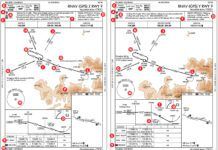
GPS with reliable guidance and strategically placed waypoints avoiding terrain can work miracles in a situation like this. Initially, that’s what the RNAV (GPS)-A looks like it’s doing.
The chart specifies magnetic because we’re at 68 degrees north, which is the edge of magnetic courses making any sense at all. The chart also offers grid courses—I won’t pretend any expertise on those. According to my contact, the magnetic guidance works just fine.
Unfortunately, it also leaves you 4000 feet above the airport.
It’s the Missed, Stupid
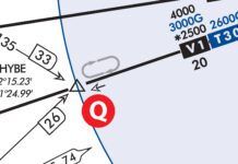
The reason for the high MDA is the terrain for the missed approach. This seems illogical on first glance because the valley widens to the northeast along the course of the missed. In fact, it’s practically a flat plain from INTON all the way up to Barrow, Alaska.
Missed approaches demand wider tolerances and anemic climb gradients, and that’s the rub. The first version of this approach actually had an MDA nearly 1000 feet lower, until a survey revealed missed-approach penetrations that required amendment 1 and the current MDA. (Amendment 1A, shown, was simply a notation change.)
The missed is also a bit of a haul—it’s 64 miles back to AKUMY. Add about 15 to fly the racetrack (seven miles per side), and you’ve gone 90 miles before you can try the approach again. On the plus side, after that much time the weather has probably changed. Twice.
Breaking out at an MDA of 4000 feet AGL only 0.4 miles from Runway 02 pencils out to a 10-degree descent. So if you don’t break out long before UPINE, plan to circle and lose 3000 feet on left downwind for Runway 20. Or make a teardrop or other reversal to come back around for Runway 02.
Or you can just forget the whole thing and get a visual descent out on the flatlands to the northeast and scud run to the airport, which is what the locals used to do and pretty much still do.
Looking for Ideas
This leaves an essentially useless, circling-only approach. Can’t we do better?
There is an RNAV departure procedure from Runway 02 that gets you safely to altitude along essentially the same path as the missed. It requires weather of only 400 and two, which would be terrific minimums for the approach. However, it also requires a climb gradient of 430 feet per mile up to 6300 feet, which is right about where our approach leaves us off. We can’t use the RNAV departure for a better missed approach.
What about reversing the approach to come in for Runway 20? Again, that’s something the locals do.
And again, the missed approach is the problem. Needing 200 feet per mile, there’s no way to get up to 7400 feet at GESTE from the runway. And the actual altitude you’d need would likely be higher due to the greater demands for clearance on the missed compared to the final segments of the approach. The fact that there’s no RNAV departure from Runway 20 at all leads to the same conclusion.
How about an approach from the north to INTON at some low MDA? If you reached INTON at, say 2000 AGL, and didn’t have ground contact, you could execute a turning missed to the northeast with clearance and head up to Barrow for a cup of coffee. If you got below the clouds, continue to the airport.
Sure, the only thing actually at INTON is some guy practicing for the Iditarod, but all the local pilots know the way.
The problem here is that “see familiar rocks and know the way” is not listed as one of the required visual references per 91.175 (c)(3) for descending below MDA and flying past the MAP.
Enter a little-used TERPS tool: the charted visual segment. Charted visual segments are rarely seen in these days of precision GPS guidance, but this kind of situation is exactly what they’re for.
The charted visual segment is part of the approach that begins at the MAP and sets required visibility for continuing visually, but it doesn’t demand seeing the runway environment. That’s a plus because it’s about 13 miles from INTON to the runway. Essentially, the charted visual segment is an approach to a point in space from which you can scud run or not as you see fit.
On approach charts, the visual segment is marked by a dashed line and often the notation, “Fly visually to the airport.” While it’s not a complete get-out-of-jail-free card, the visual segment isn’t bound by the missed approach requirements. Like a circling maneuver, it’s part of the published approach, but the assumption is you won’t execute a missed.
And what if you do need to fly a missed from somewhere down the charted visual path? You’re now an on-the-fly approach designer. Do whatever necessary to get back on a charted black line at a safe altitude. When you get to Barrow, have whiskey instead of a coffee.
So, So Safe or So-So Safe?
That’s just the reality of approaches snaking down through terrain. There’s only so much protection they can afford, and every technique getting you closer to the runway has a price somewhere in technical requirements or options if something goes wrong. The controller reports the winds to help adjust your hold.
Even under the best of circumstances, this airport is not for the faint of heart. The notes warn that the steep terrain may cause unexpected turbulence, suggest a flyover to check the condition of the runway before landing, and remind that wildlife (human and otherwise) may occupy the runway unexpectedly.
The Alaskan pilot and I agreed it was worth pursuing with an approach consultant to see if a new approach with a charted visual segment could yield an approach folks would actually fly.
To illustrate the need, he shared a few photos of wreckage he saw on the same day he first flew this approach. A bit before the airport lay the remains of a Cessna Caravan that had a premature encounter with the ground. The people were fine, but the aircraft had reached its permanent end of the road.
Jeff Van West self-describes as a high-tech Luddite.There are days when his pockets contain asmartphone and a wind-up pocket watch. Really.


