
At first look, the title VOR or GPS RWY 13L/R approach [A] presumes a straight-in approach to two runways or that the final approach course alignment is 30 degrees or less to the runways. But look again. There is approximately a 90-degree difference between the final approach course and the runway headings; it is neither a circling approach nor a side-step maneuver. There are also 3.6 NM and 2.6 NM visual segments [B] from the missed approach point (MAP) to Runway 13L and Runway 13R, respectively.
Because Canarsie does not meet straight-in approach requirements, a max change of direction of 30 degrees or less, and it is not a circle-to-land approach (CTL, with only circling mins), and it mentions both L and R on the same chart, a waiver was required for the somewhat ambiguous title. Even an FAA rep mentioned to me: “It is definitely unique!”
Background
For historical context, I spoke with a retired airline captain who flew this approach many times over his career. He mentioned that “It was an interesting and fun approach.” Canarsie Approach is not the official name, but over time, it was adopted by pilots since it is based on the Canarsie VOR/DME (CRI). It dates back to the late 1950s when JFK Airport was known as Idlewild (KIDL), named after the Idlewild Beach Golf Course, where the airport was built in the Borough of Queens. At that time, jets (Boeing 707 & DC-8) were replacing four-engine piston airliners (DC-6, DC-7, and the Lockheed Constellation series). Additionally, the approach speeds increased from about 110 KTS for the piston airliners to about 140 KTS for the jets.
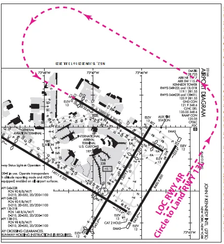
A major airline took the initiative to develop and adopt the Canarsie Approach. Before the approach, when the winds favored the southeast-facing runways (13 L & R), the procedure was to fly the 4R LOC to a CTL MDA of around 700-800 feet MSL (about the same AGL). Fly the length of Runway 4R, then a left turn to a left downwind to Runway 13L, followed by a 180-degree left turn to Runway 13L. With the higher jet approach speeds, the CTL maneuver with a change in direction of 270 degrees resulted in a somewhat sporty experience, especially in marginal weather conditions. Noise consideration was another critical factor in adopting the Canarsie Approach since it minimizes the footprint over built-up areas compared to straight-in approaches to Runways 13L and 13R.
The Canarsie Approach
The approach originally started as a VOR-only procedure using the Canarsie VOR/DME (CRI) [C] as the primary NAVAID, and later with the advent of GPS, it became a GPS overlay approach. The “or” in the procedure name indicates that it can be flown with VOR or GPS. If flown with GPS, monitoring the CRI VOR is not required but is a good practice. Overlay approaches were common in the early days of GPS to encourage their use. Most overlay approaches are now gone, but not the Canarsie. The advantage of overlay approaches was that the flight paths were already surveilled based on the underlying ground-based NAVAID(s). In designing overlay approaches, navigation fixes based on VORs, DMEs, and/or NDBs only had to be modified as GPS LAT/LON waypoints.
As noted, DME or RADAR is required, [D] but GPS can be used instead of DME. Depending on the landing Runway 13L or 13R, Kennedy Tower frequencies differ. [E] This approach uses Runway Lead-In Light System (RLLS) consisting of sequenced flashing lights. [F] The procedure is not authorized if the lead-in lights are inoperative. [G] The approach starts at ASLAT (the IAF), which can also be identified using the 105-degree radial of Solberg VOR/DME (SBJ) at 3000 feet MSL (or 2000 feet MSL) [H] direct to the Canarsie VOR/DME (CRI) (Final Approach Fix) and on to the Missed Approach Point (DMYHL). [I]
At DMYHL, a decision is needed—continue or go missed by climbing turn direct to Deer Park VOR/DME and hold. [J] Or proceed to the first set of RLLS (Old Mill Creek RLLS). [K] Then, for RWY 13L, the Lefferts Boulevard RLLS [L], followed by the Hotel RLLS [M] and the Runway 13L RLLS. [N] For Runway 13R, after Old Mill Creek RLLS, Runway 13R RLLS. [O] The approach can also be timed from the FAF (CRI) to the MAP (DMYHL). [P] Additionally, Runway 13L has a CAT II Approach Lighting System (ALSF-2) [Q]; however, while not indicated on the chart, Runway 13R has a Medium Intensity Lighting System (MALSR).
While the two runways share the same approach chart, loading the approach with a Garmin GTN series navigator, each runway has its approach. However, once loaded, there is no difference between the two. It makes sense because it is a visual maneuver after DMYHL, with eyeballs looking out for the desired track using the relevant lead-in lights.
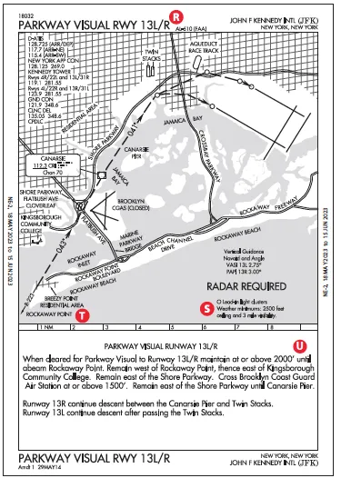
Parkway Visual RWY 13L/R
The Parkway Visual [R] is another option. It is a Charted Visual Flight Procedure (CVFP) and is not an instrument approach because it does not have a published missed approach procedure. CVFPs are designed to consider environmental/noise factors and, when necessary, for efficient ATC operations. Typically, they depict prominent landmarks and some NAVAID information for additional guidance—here, the CRI VOR/DME. The weather must be VMC.
According to AIM 5-4-24, ATC will not issue an approach clearance until a pilot sights a charted visual landmark. If the approach cannot subsequently be continued, for example, losing sight of a preceding aircraft, missed approaches will be handled as go-arounds since there’s no missed approach procedure.
Unlike an instrument approach, the Parkway Visual has a ceiling requirement, specifically a ceiling of at least 2500 feet AGL. Additionally, three-mile visibility is needed and would be considered marginal VFR based on the visibility requirement but not the ceiling. [S] The ceiling is relatively high for VFR, but it is required to identify the first visual reference: Rockaway Point at or above 2000 feet MSL. [T]
Parkway Visual starts at or above 2000 feet MSL. [U] It requires a familiarity with the various visual references starting abeam Rockaway Point, then Kinsborough Community College, along the Shore Parkway, near the closed Brooklyn Coast Guard Air Station, then Canarsie Pier (not the Canarsie VOR), followed by the Old Mill Creek lead-in lights. Overfly the other relevant lead-in lights of the Canarsie approach to the landing runway. The Canarsie VOR provides additional course guidance (radials 223-degree inbound and 041-degree outbound). The ground track is similar to the Canarsie Approach.
Visual Approaches
As a reminder, a typical visual approach is conducted under IFR in VMC. It allows the pilot to proceed visually and clear of clouds to an airport, typically requiring basic VFR: at least 3 SM visibility and a ceiling of 1000 feet AGL. ATC will authorize a visual approach when operationally beneficial compared to an instrument approach, or the pilot may request it. However, ATC retains responsibility for traffic and wake-turbulence separation. Similar to CVFPs, there is no published missed approach; if the aircraft cannot maintain VMC to the airport or for any other reason, it is treated as a go-around.
GPS Navigator Considerations
GPS navigator databases like in the Garmin GTN series, lack the Parkway CVFP; however, they do have visual approaches to both Runways 13L and 13R. But be careful. These visual approaches show an extended runway center line to about 20 NM and provide a three-degree-advisory glidepath. The glidepath has not been surveilled for obstacles. Given the traffic realities of the New York metropolitan area, the Garmin visual approaches would probably not be flyable from 20 NMs out.
2021 Update
In 2021, two new approach procedures were introduced, specifically the RNAV (GPS) Z RWY 13R and RNAV (GPS) Z RWY 13L. They are flown to LNAV MDAs of 940 feet MSL and 1260 feet MSL, along with required visibilities of 3 SM and 2 SM for 13R and 13L, respectively. Perhaps these might replace the Canarsie Approach someday, but the MDA for the Canarsie approach is 800 feet MSL, so it might not be as useful. [V]
Luca F Bencini-Tibo would like to remind anyone who has been to Idlewild as a pilot or passenger before the name change to rest assured that the ICAO airport code (KIDL) survives at the Indianola Municipal Airport in Indianola, Mississippi.


