As you probably know, there have been two powerful forces that address the possibility of reducing but not eliminating circling approaches. First, that’s a good thing because circling approaches in low IMC are much higher risk than landing straight in. One force is the proliferation of straight-in RNAV (GPS) approaches to many runway thresholds, many of which can be flown to Localizer Performance with Vertical Guidance (LPV) ceiling and visibility minimums.
Secondly, there is a draft FAA policy issued on June 28, 2018, to reduce the number of standalone circling approaches and eliminate circling minimums on some straight-in approaches, particularly ILS and RNAV LPV approaches. The draft FAA policy makes it clear that the reduction of circling approaches is not part of the VOR minimum operating network (MON) initiative.
Do You Want to Circle?
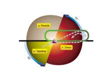
Nevertheless, the instrument rating Airman Certification Standards (ACS) requires circling approaches: “Circling Approach: Maneuver the airplane, at or above the MDA, 90 or more from the final approach course, on a flight path permitting a normal landing on a suitable runway.” Clearly, we’re supposed to be able to circle.
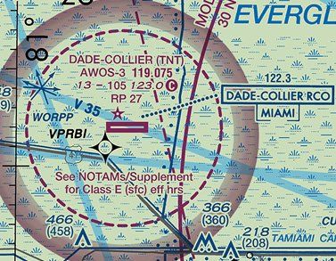
Let’s consider a situation. We are flying over the Florida Everglades in low IMC. Our alternator just died, which clearly counts as an emergency in IMC. So, we must land. Now! Wind is blowing from the west at 25 knots and we are close to Dade-Collier Transition and Training Airport (KTNT). Although it used to have three approaches to Runway 9—an ILS, an NDB and an RNAV—the only one now available is the RNAV (GPS) RWY 9 approach. With that wind, we certainly will not be landing on Runway 9, even though the runway is 10,500-feet long.
We could consider using Runway 27 instead but will have to do a circling approach with one-mile visibility and a minimum descent altitude (MDA) of 400 feet or higher, depending on approach category. We chuckle for a moment at the old concept that legal doesn’t necessarily equate to safe as we realize that there’s no way we want to be circling an unfamiliar airport at less than 400 feet AGL and only a mile visibility.
What are the alternatives? We could still go ahead and circle to land on Runway 27 or go to another airport with favorable winds with straight-in approaches, perhaps even with vertical guidance. In thinking about going elsewhere, we think about the battery and can’t remember the last time it was replaced. We might not have many more electrons, and if the battery goes, we’ll be completely out of options.
Fly a Visual? In IMC?
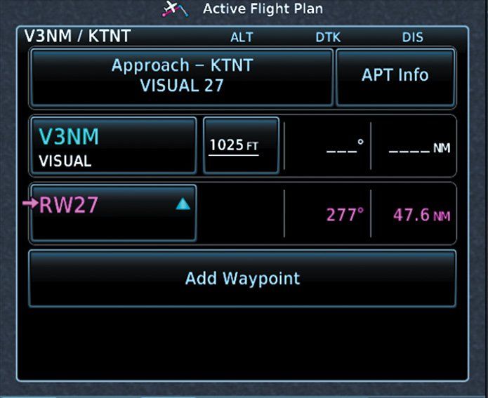
But we have another choice. We all know that visual approaches and charted visual approaches (See “Charted Visuals” in IFR Magazine, February 2018) are legitimate approaches issued to IFR traffic during operations in VMC. But there is another visual approach that is available. Call it the G-Visual for Garmin Visual. It’s available in Garmin navigators such as the GTNs and later model G1000’s. It uses WAAS to provide straight-in lateral and vertical guidance to many runway thresholds, even if a runway already has a straight-in published approach. It is a safety feature, especially when flying VFR into a new airport or approaching an airport at night.
Before we discuss this option further, first please read the sidebar. Done? Now, read it again. I’m serious; I’ll wait.
If this becomes your chosen option in IMC, and considering the surface-based controlled airspace, it must be done under a declared emergency. We do get some protection from the regulations that we should definitely use. Part 91.3(b) states, “In an in-flight emergency requiring immediate action, the pilot in command may deviate from any rule of this part to the extent required to meet that emergency.”
So, there it is. If you declare an emergency, you go do what you need to do. If that means flying a visual approach procedure that’s not been surveyed or flown for obstacle clearance, then you do it and hope for the best.
There are many airports that don’t have published approaches; however, this number is shrinking over time. Take for example Everglades Airpark (X01) on the southwest coast of Florida nestled among mangroves, swamps, and brackish water (but excellent stone crabs in Everglades City). The airport does not have any published approaches but has G-Visuals for Runways 15 and 33. Of course, these are not instrument approaches and are intended to provide supplementary guidance only in visual conditions. But, as above, if I found myself in a serious emergency and absolutely needing to land at X01 in IMC, even though it is uncontrolled Class G airspace from the ground up to 1200 feet AGL, I would still declare an emergency because I would most likely be descending from controlled airspace.
Bottom Line
G-Visuals add a level of safety in providing many runways with lateral and vertical guidance that is especially useful at unfamiliar airports and at night, but strictly for VFR use. G-Visuals all use a three-degree glideslope but it has not been properly surveyed. So, pilot beware. But if an emergency calls for an immediate landing in IMC, a G-Visual is better than blind flying. However, it has to be treated as an emergency procedure, and that means declaring an emergency and squawking 7700. And don’t forget to write-up a NASA report.
No, It’s Not Legal. But Is It Safe?
Safety is relative. For example, walking alone at night could be safe or dangerous depending on where you are. There are degrees of safety and to answer the leading question requires looking at the big picture.
If you’re planning a flight to an airport where the available approaches don’t suit you, no, merely flying the G-Visual is not safe. But, add our scenario where the weather is at minimums (or a bit below), you’re running on battery alone and doubt there’s enough battery to get you safely to another airport, then a G-Visual becomes more attractive.
Again, it’s degrees of safety. Which do you think would be safest in the scenario in the article? Would you land on Runway 9 with that tailwind? Would you circle to Runway 27 on the Runway 9 approach? Would you risk ending up completely dark by going elsewhere? Or would you use the guidance from the G-Visual approach to land straight-in on Runway 27?
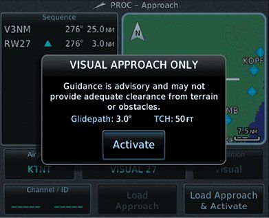
Garmin says visual approaches will be available to any runway in the database that includes specific position data for both ends of the runway. The GTN 750 Pilot’s Guide adds this about their visual approach procedures: “The availability of vertical guidance advisories for visual approaches is dependent on terrain and obstacle obstructions along the approach path. If no known obstructions are within the approach path, vertical guidance is provided to a maximum distance of 28 NM from the runway. If there are known obstructions further than 3 NM, but within the 28 NM maximum distance from the runway along the approach, vertical guidance is limited to the approach path portion after crossing the known obstructions. This is indicated by the shortened magenta line on the map after loading the approach. If obstructions are within 3 NM to the runway, along the approach path, advisory vertical guidance is not provided. Lateral guidance is always provided for visual approaches.
“Published data is used to determine the visual approach GPA and TCH for the selected runway. If no published data is available, the default is 3 GPA and 50 FT TCH.”
It continues with a note: “If the GTN does not have a valid terrain database, advisory vertical guidance is not available for visual approaches.”
To drive this home to the pilot, once a visual approach is selected, one of two cautionary messages pops up, with the difference being between displaying the glidepath angle and threshold crossing height as shown in the note depicted, or simply displaying “NO VERTICAL GUIDANCE” to stress that fact that Garmin doesn’t think the computed glidepath is safe. —FB
Luca Bencini-Tibo hasn’t had to do this. But now that he’s researched it, he’s prepared if he is ever left with that as the best option.

All this is great if you are equipped with a modern Garmin stack. However, not all are equipped with this type of avionics package or an equivalent. Therefore, teaching the basics with an absolute minimum of equipment and practicing this frequently is paramount for any type of flying regardless if it is VFR or IFR flying. It’s amazing to me that with all this new technology in the cockpit that most forget that airplanes still fly the same as they have always flown if they lose or cannot bring up their magical line. The results of this are typically a pilot over controlling the airplane while focusing on the wrong things. With everyone’s attention focused inside the cockpit looking for that magical line, I have noticed a disturbing trend downward in the last 10 or so years in my 31 years of teaching in the pilots situational awareness and the ability for the pilot to understand what they see once they have broken out of the clouds. I’ve seen this even in VFR flying when coming into an unfamiliar airport with clear skies and no wind. If the box doesn’t show them the procedure to follow, they are lost. This isn’t solely on newer pilots either. This is across the board and I primarily teach in turboprops now. This is a bad thing. Circling to land is not a new thing and is not anymore dangerous than any other type of approach if the pilots are trained properly from the beginning. Why people tend fly the plane differently when flying at circling minimums when the weather is at 7000ovc compared to 700ovc is amazing and it all comes down to proper training and practicing what was taught. On any IFR flight, you should know way in advance of starting your approach if you will be circling and should have your plan in place. There are many airports that I frequent that we circle to land as a norm and it’s always a shocker when the winds favor a straight in approach to a landing. Technology can play a wonder part in flying but I do not believe more technology to rely on is the answer for an increase in safety as well as a way to get a round a circling approach when it can be done safely. Everything must balance and pilot complacency appears to be what is making this equation unbalanced. This seems to be an unintended consequence of all this wonderful technology we have at our fingertips.
Brett James I can’t agree with you more. I am an ATP Airplane/Helicopter. CFi, ii, MEi, ii, AGi. Since 1977, I have over 12,000 hours in airplanes and helicopters, up to the B727-200 and UH-60A to a C150 and Bell 47-D. I too have notice the loss of situational awareness in pilots that fly glass flight-decks. I attribute this mainly to the LACK of training in both initial and recurrent situations. Companies I have worked for hand you a manual of a glass system and tell you, “Your trained”, now go fly the customer. Very difficult to tell the boss they need to spend money on actual training. My two bits.
Garmin belongs in your car.
Suggesting to use the Garmin GTN-750 visual option in this circling situation is basically irresponsible and certainly dangerous. Given you own comments about this visual option not be surveyed for obstacles and then to suggest it be used is an IFR low altitude and ceiling environment… confusing at least, extremely bad advice at best. This “Garmin visual” option was introduced as a tool for stabilizing approach VFR arrivals. It was never intended to be used in the IFR environmental as a non-surveyed approach. Additionally, given the situation described in this article (failed or failing electrical system), one would want to get the airplane on the ground immediately if possible even with a 25 knot tailwind.
Landing on Runway 9 with a 25 knot tailwind in this situation is very acceptable and not dangerous at all in most if not all GA airplanes especially with 10,500 feet of runway. Typical GA airplane POH’s include performance numbers for a 10kt tailwind and typically adds 30-40% increase in the landing distance over a 50 ft obstacle. A 25 kt tailwind on average would on average double the landing distance. With the typical GA airplane requiring approximately 1,500 feet to land over a 50 ft obstacle, this would mean a total landing distance of 3,000 ft or even 4,000 ft under this wind condition.
The landing distance of 4,000 ft with a failed or failing electrical system on a 10,000+ foot runway is far better than using non-approved approach guidance and circling at 400 ft AGL in the weather.
I agree in this scenario I would probably also land straight in with the tailwind, but I appreciate the efforts of this article.
I get that the point is, in a situation where _everything else_ is more dangerous, the G-visuals are still there and could possibly be useful. The background info when and why the Garmin visual provides vertical guidance is definitely essential to know, especially in IMC conditions or at night.