Put It Together: DIY SOP
Weve discussed the benefits of personal standard operating procedures (SOP) for our own flying. Weve taken the main elements (Using an SOP in GA, September 2016) and began creating our own (DIY SOP Considerations, February 2017). Meanwhile, we tried to wean you from your do-list in favor of a flow and check (Change Your Checklist, October 2016 and DIY Flow and Check, January 2017). In this final article, we assemble a personal SOP for a light GA single.
Handling Windshear
Really big winds and airplanes are not compatible. Of course, our first desire is to avoid those big winds. But, occasionally they sneak up on us even when were diligent about avoiding them. Then what should you do?
The Weather Aloft
In Wx Smarts, we go beyond the basics you learned in flight school. Sure, you know that winds are stronger at higher altitudes, and that you find fronts near where the jet stream is, but why? What makes the winds flow from the southwest at 20,000 feet when theres a storm system approaching? Lets go past the usual weather playbook to look at why the given upper-air pattern is in place.
Going Downhill Fast
Keeping your instrument-flying skills sharp is like high school football. No, not the social activities after the game; we mean the combination of drills and scrimmage. This sim challenge is a bit of both. The scrimmage part is that youll practice in the context of a (nearly) complete flight. The drill part is that flight is focused on one skill: the anvil descent.
Charting Two for One
The note is correct as written-and an IFR GPS alone is fine. Now follow me down a logical rabbit hole to understand why, as well as see how GPS and digital tech in general are changing how we fly IFR.
Stormy Encounters
While we certainly dont need to examine weather accidents to remind us that weather can be a killer, reviewing them can be a good teacher. The accidents well review attracted only a couple paragraphs in the local newspaper and were quickly forgotten, but every incident has the potential to save lives. Well try to understand their story by digging into radar and weather data and poring through the NTSB archives and try to find just how these pilots got themselves in trouble and what lessons we can learn.
DIY Weather Briefing
The old saying tells us you cant be cleared for takeoff until the gross weight of the paperwork exceeds that of the aircraft. That hasnt changed much since Flight Service received reports on Teletypes necessitating cryptic abbreviations to conserve precious bandwidth on 75-baud lines. Calling Flight Service used to be required to file a flight plan and get a weather review from a specialist with information unavailable anywhere else. Technology has changed all that.
Displacement Effect
Displaced thresholds are just for landing in the direction of the displacement. So back in 2008 when the 4800-foot runway was displaced 1500 feet from both ends, the landing distance either way was 3300 feet. You may roll out, or even touch down and stop, on the displacement for the opposite direction.
Fronts
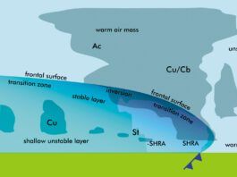
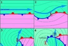
Fronts in TAFs and weather briefings often mean a day of delays and canceled plans. Considering the impact that they have on flight operations, we should understand fronts. Lets study them so you can make a good guess about the resulting weather. Our modern knowledge of fronts began around 1910 in the Bergen School of Meteorology in Norway. Their early work laid out the mathematics of forecasting and described fronts, showing that they are defined by a change in air mass density. Changes in wind speed, humidity, or pressure are all secondary.
Readback: March 2017
Jeff Van West is one of my favorite modern-day aviation writers. His article, Seeing Double in the November issue is a fine example of Jeff taking us by the hand through important, but oft overlooked and esoteric aspects of our IFR life. But his use of the word declination instead of the correct word, variation, is a fingernail on the blackboard kind of irritant, if you remember blackboards. I have these old yellowed books that I studied in the 50s: AF Manual 51-40, Air Navigation Vol 1, by the Department of the Air Force (1959), page viii, and The American Flight Navigator by John Dohm (1958) page 324.
Why It’s So Bumpy
I recently got a question from a reader: When you are flying in clouds and the ride is bumpy, is it bumpy because its cloudy or is it cloudy because its bumpy? Good question. Turbulence is often approached from a rather pragmatic approach in aviation, and that often leaves pilots with questions about where it fits in with weather patterns. Lets look at this piecemeal. From a meteorological perspective, turbulence is bumpiness caused by flight into an area where wind is changing over a small distance.
Forecast Accuracy
Walk into any flight operation and theyll tell you that safety is the top priority. As of 2016, accident rates across the board from GA to commercial operations have fallen to an all-time low. This is thanks to the cooperative efforts of pilots, controllers, technicians, instructors, and the organizations that support them. Given the great improvements in safety and the stringent standards that apply to everything from replacement of a torque link bolt to the handoff of an aircraft by ATC, it might seem strange that were approaching the year 2020 and busted TAFs (Terminal Aerodrome Forecasts) are still a fact of life.
