Free-Flying
Youre living the good life and working the system-the tax system. You work in Portland, Oregon, with no sales tax, but live across the river in Vancouver, Washington, with no income tax. So, you can at last afford that glass-panel bird. After flying it across the U.S. to bring it home, its finally time to load the last approach of the trip: The LDA-A into Pearson Field in Vancouver (KVUO). Except the approach isnt in the GPS database.
March 2016
Cirrus Aircraft officials had been hoping to deliver the first SF50 Vision jet by the end of last year, but the company said in January that schedule has stretched to sometime in the first half of this year. Mooney International Corp.s M10T proof-of-concept model completed its first flight, in December, from Chino Airport in California. The M10T, unveiled in 2014 at the Zhuhai Airshow in China, is aimed at Chinas flight training market, and will be manufactured there. The FAA launched its drone registry in late December, and within the first three weeks, about 180,000 drone users had registered. In the NTSBs annual list of most-wanted safety improvements for aviation, loss-of-control accidents repeated from last years choice for general aviation. Anticipating that Congress will consider changing how the FAA is funded in this years spring session, 15 general-aviation advocacy groups signed a letter in December asking the U.S. House to hear their real and long-standing concerns about the expected proposals.
March 2016
Basic altimetry is well covered in various texts, but some aspects can be confusing. Theres not enough material for a full article, but here are a few basics. To my knowledge, the only reason that a speed restriction would be used on an ODP is to reduce the turn radius. Since this procedure has a defined route, thats probably whats happening here. Regardless of their ability to actually see the airport, they were flying under IFR in weather below VMC.
Staying On Top of GPS Navigation
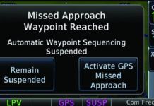
How does your GPS navigator handle a leg to a specific heading or to a specific altitude? Do you fly these with the confidence of Captain Picard of the Enterprise, or of Doctor Who pushing a button to see what happens? These legs are common, particularly as the first step on a missed approach: Climb runway heading to 1300, then ...
Flying Into Procedure Turns
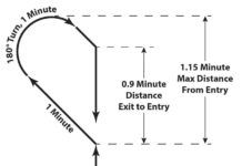
It seems pretty obvious-start the procedure turn (PT) past the remain within fix and dont exceed the specified distance. But, there are other considerations such as having enough time and distance to make the FAF altitude inbound. Then, theres the Buchannan Field VOR Runway 19R approach at Concord, CA (KCCR). Here, the chart clearly shows that the procedure turn begins after HUKVI. Or does it?
IFR Around the World
Lessons came from all around the world. The instrument flying I learned applies almost 1:1 overseas. Yet, subtle nuances-often procedural-coupled with psychological perceptions of difference, did come to light. For example: While its one thing to be between stations over the Rockies, what about in Bangladesh?
Tale of Two Approaches
Most approaches of the same type, particularly RNAV (GPS) approaches, seem essentially the same. The fixes and the minimums are different, but just about everything else is similar enough to other approaches to give a proficient pilot a been there, done that feeling. This thinking can lead us to simply check that the weather is good enough before departure, rather than actually studying the entire procedure before launching.
Practical Logging
On the heels of the controversy about logging time in a simulator, the FAA has given us an InFO that unequivocally provides clear guidance about when we can log an approach. Thats guidance that weve been lacking, so were glad to see it.
Weather Multitasking
For the moment, well begin with a nickel tour of both the ATC and the national aviation weather systems. Naturally, theres some overlap between them. The FAA air traffic control system is one big ol network. The chain of command begins with the ATC System Command Center in Virginia, which provides oversight and coordination between the biggest ATC facilities, the Air Route Traffic Control Centers.
Can You Log That?
Within the IFR community, there has been much confusion over how and when to log instrument approaches. The FAA extended that confusion to logging approaches in a simulator as we wrote in the December issue, Need a Sim Instructor?
Loss of Control
Loss of control in-flight (LOC-I) is the leading killer in GA, with more fatal accidents than the next six causes combined. The Colgan 3407 and Air France 447 crashes brought LOC-I to the forefront. Were forced to ask how we can lose control of perfectly good airplanes. The American Institute of Aeronautics and Astronautics identified LOC-I as the most significant cause of commercial aviation fatalities worldwide.
Five Lines of Minimums
There are some things that you never expect to see together, and they surprise you when used in the same context: West Texas referred to as alpine, Donald Trumps name beside front runner, and hashtags on approach charts, I cant explain that second one, but the first and last make sense when digging into the RNAV (GPS) Rwy 19 approach at E38, a.k.a. Alpine, Texas.


