How Can They Do That?
We have some Pilots and even CFIIs flying contact approaches into S50. The regulation for contact approach requires both flight and ground visibility of one mile. While there is some weather reporting on the field it doesn’t include any kind of visibility. Aren’t they breaking the rules? Shouldn’t ATC Approach know this isn’t allowed and refuse to give this type of clearance?
Dan Anderson
Auburn, Washington
This is a good question and we referred it to our regs guru, Mark Kolber. He discusses ground visibility only. Visibility in flight is determined by the pilot, just as it is for any approach. However, if the visibility is marginal, be prepared to explain how you determined that it was sufficient, should an inspector ask. Mark replied:
AIM 5-4-25 and 5-5-3 both require one mile flight visibility and 5-4-25 says, “The reported ground visibility at the destination airport is at least 1 statute mile.” That’s 5-4-25. The way the AIM is worded, the ground visibility burden lies with ATC. ATC is not supposed to clear for a contact approach before ascertaining “that reported ground visibility at destination airport is at least one mile (5-5-3.b.). “The reported ground visibility is at least 1 tatute mile” requirement is repeated in the 7110.65.
According to the S50 RNAV-A approach chart, the official weather source is the SEA AWOS, which is eight NM away. We would guess that ATC is clearing contact approaches at S50 based on ground visibility at SEA. But, you later told us you observed this at least once when the visibility at KSEA was well under a mile. So, we’d suggest reaching out to Seattle TRACON and asking.
Radar Altimeter 5G Hooey
The mainstream media reports on the effect of 5G on air operations have been confusing to me. The first news I heard stated the 5G spectrum that was auctioned to telecommunications companies could affect “radio altimeters,” I thought to myself, “What are they talking about?” And these early news reports had an attitude like, “This equipment is needed to tell the pilot how high they are, so it sounds pretty basic, pretty important, really scary.”
Subsequent news reports started calling them “radar altimeters” so I started to get a better idea what the news was talking about. If I were flying an F-111 at Mach speeds a couple hundred feet above the ground, a ground proximity radar would be pretty important to me, but do I need one in my slow and dinky plane? Oh, the approaches? Am I violating §91.13, being careless and reckless for ever leaving the ground without a radar altimeter?
Last week, I heard this airline captain interviewed and he was rather alarmist. But this was the first time I thought of the problem of the radar altimeter being linked to lots of other systems. It seems the pilots might never realize the radar altimeter is producing bad data, and the autopilot, “George,” might become our version of HAL 9000 (“I need to land here, George.” “I’m sorry, Dave. But, I can’t let you go any lower.”)
What’s all the hubbub?
Paul Huffman
White Salmon, Washington
Those are good questions about the radar/radio altimeter, Paul. So good, in fact, that we’ve written a whole article to answer them as well as to provide a lot more information. Please see the article “The 5G Brouhaha” on the very next page.
Thanks to Tim Vasquez
I just wanted to say that I appreciate the work Tim Vasquez puts into his Wx Smarts articles. He has turned weather, a subject for which I had very little enthusiasm, into an area of interest. Yes, even the Skew-T charts.
Watching his weekly videos on Forecast Lab and his YouTube channel, have also given me a lot of useful information. Hope you guys can keep him around!
Jake Radermacher
Shipshewana, Indiana
Thanks for the kind note, Jake. Yeah, we plan to keep Tim involved as long as he’s willing. We think he hits that sweet spot in weather information between too esoteric and too simple—exactly what we need for “the accomplished pilot.”
MSL? AGL? What…?
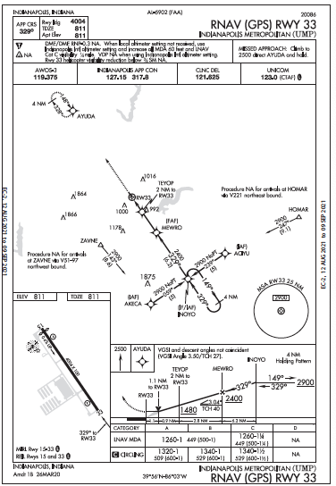
In the January Clinic, “Tight on Fuel,” Elaine Kuah says in her hypothetical trip that Indie Metro has an LNAV with 1260-1 minimums.
She says, “You’ll need it as the latest forecast is for 500-1.” How will that help when the weather at Indianapolis Metropolitan is 40 percent of those minimums? Plus, making matters worse, the prognosis is poor because two nearby airports already have even worse forecasts. I would scrap Indie Metro as a waste of time and fuel. There is, as we all (should) know, no room for hope in a cockpit.
 Anecdotally, we know Murphy turns good forecasts into bad ones and bad ones into worse ones. This one is a bridge too far.
My fairy godmother of aviation is, I imagine, an elderly GS-9 with weak kidneys. Despite that, she has protected me from doing stupid stuff and turned many breaks in my favor. Even her magic could not be expected to save this one.
Monty Watson
Daytona Beach, Florida
With a reported ceiling from AWOS at 500 feet and the ground at 811 feet, what’s the MSL of the ceiling? How does that compare to an MDA of 1260 MSL? Monty, have you perhaps been flying in Florida too long, where you can effectively ignore any difference between AGL and MSL?
Consider a similar scenario in Durango, Colorado. Say you’re flying the RNAV (GPS) RWY 3 approach to LPV minimums of 6843. Say the reported ceiling is the same 500 feet. Will you make it in? (Answer: Yes. No problem. The airport elevation is 6689 feet. With a 500-foot ceiling, the clouds will begin at 7189 feet MSL. Minimums of 6843 should be trivial with over 300 feet to spare.)


